IMAGES TAKEN NEAR TO
Boyd Orr Walk, ABERDEEN, AB12 5SE
Introduction
This page details the photographs taken nearby to Boyd Orr Walk, AB12 5SE by members of the Geograph project.
The Geograph project started in 2005 with the aim of publishing, organising and preserving representative images for every square kilometre of Great Britain, Ireland and the Isle of Man.

There are currently over 7.5m images from over14,400 individuals and you can help contribute to the project by visiting https://www.geograph.org.uk
Image Map
Images are licensed for reuse under creativecommons.org/licenses/by-sa/2.0
Notes
- Clicking on the map will re-center to the selected point.
- The higher the marker number, the further away the image location is from the centre of the postcode.
Image Listing (12 Images Found)
Images are licensed for reuse under creativecommons.org/licenses/by-sa/2.0
Image
Details
Distance
2
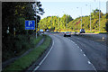
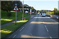
Stonehaven Road
Main road into Aberdeen from the south, seen here before it was dualled.
Image: © Colin Smith
Taken: Unknown
0.12 miles
3
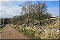
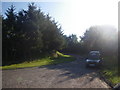
Unnamed Lane
Although the maps don't name it, I am sure the local residents will have a name for it. It is a handy short cut between Stonehaven Road and Redmoss Road, and seems to be maintained to a high standard.
Image: © Anne Burgess
Taken: 20 Mar 2020
0.12 miles
4
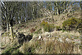
A Gap in the Dyke
Until I came close to this, I thought it was a conveniently sited path, but it isn't. It is to allow water to drain off the lane into the patch of scrubby wood.
Image: © Anne Burgess
Taken: 20 Mar 2020
0.14 miles
5
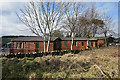
Craighill Holiday Park
The map says 'caravan site' but there are now only static caravans and wooden lodges.
Image: © Anne Burgess
Taken: 20 Mar 2020
0.14 miles
6
Stonehaven Road, Bridge of Dee
Shell filling station on Stonehaven Road (A92).
Image: © David Dixon
Taken: 24 Sep 2018
0.15 miles
7
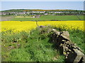
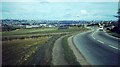
Craighill Kincorth in background
Hills in background commonly known as the Gramps
The A90 can be seen near top of photograph beneath housing
Image: © Colin Walker
Taken: 3 Jun 2005
0.16 miles
8
Taxi parked in dual carriageway local access
Photographer is standing on paved surface not far from the A90.
Image: © C Michael Hogan
Taken: 9 Jun 2011
0.17 miles
9
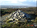
A Cairn close to Kincorth Hill
This cairn is situated on private land adjacent to the Kincorth Hill nature reserve.
Image: © George Wilson
Taken: 22 Oct 2006
0.19 miles
10
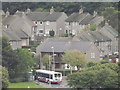
Faulds Gate
Bus terminus at the western end of Kincorth, now running to Dyce.
www.aberdeencity.gov.uk
Image: © Colin Smith
Taken: 6 Sep 2012
0.22 miles