IMAGES TAKEN NEAR TO
Kincorth Circle, ABERDEEN, AB12 5PA
Introduction
This page details the photographs taken nearby to Kincorth Circle, AB12 5PA by members of the Geograph project.
The Geograph project started in 2005 with the aim of publishing, organising and preserving representative images for every square kilometre of Great Britain, Ireland and the Isle of Man.

There are currently over 7.5m images from over14,400 individuals and you can help contribute to the project by visiting https://www.geograph.org.uk
Image Map
Images are licensed for reuse under creativecommons.org/licenses/by-sa/2.0
Notes
- Clicking on the map will re-center to the selected point.
- The higher the marker number, the further away the image location is from the centre of the postcode.
Image Listing (25 Images Found)
Images are licensed for reuse under creativecommons.org/licenses/by-sa/2.0
Image
Details
Distance
1
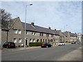
Housing in Kincorth
Blocks of 4 houses are commonly found in this post war council estate where many homes are now in private ownership.
Image: © Lizzie
Taken: 21 May 2005
0.05 miles
2
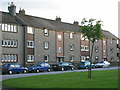
Housing in Kincorth
Close to Kincorth Hill post war housing.
Image: © Lizzie
Taken: 21 May 2005
0.05 miles
3
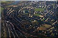
Kincorth, Aberdeen, from the air
Taken from a plane on approach to Aberdeen Airport.
Image: © Mike Pennington
Taken: 24 Feb 2017
0.05 miles
4
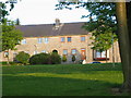
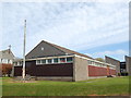
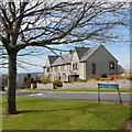
Margaret Clyne sheltered housing complex, Kincorth
Image: © Bill Harrison
Taken: 19 Apr 2014
0.07 miles
5
Abbotswell Primary School, Kincorth, Aberdeen
I guess this is the original 1930s primary school, built in Aberdeen granite on its hillside site.
Image: © Bill Harrison
Taken: 19 Apr 2014
0.09 miles
6
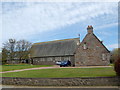
Kincorth South St Nicholas Church
Built to a rather austere design in the 1940s.
Image: © Bill Harrison
Taken: 19 Apr 2014
0.10 miles
7
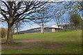
Kincorth Scout Hut...
...with Kincorth Parish Church just visible to the left.
Image: © Bill Harrison
Taken: 19 Apr 2014
0.11 miles
8
Faulds Gate, Kincorth
1930s Council houses, now mostly in private ownership.
Image: © Bill Harrison
Taken: 19 Apr 2014
0.11 miles
9
Deevale Gardens, Kincorth
Green space + fine granite terraces.
Image: © Bill Harrison
Taken: 19 Apr 2014
0.11 miles
10
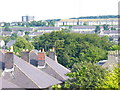
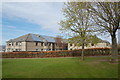
Kincorth from Ruthrieston
Kincorth was begun in the late 1930s as a garden suburb. Its streets follow the contours of Kincorth Hill and the housing scheme was a prize-winning one. The roofs in the foreground are in Ruthrieston Crescent.
Image: © Colin Smith
Taken: 6 Aug 2009
0.12 miles