IMAGES TAKEN NEAR TO
Tollohill Drive, ABERDEEN, AB12 5DN
Introduction
This page details the photographs taken nearby to Tollohill Drive, AB12 5DN by members of the Geograph project.
The Geograph project started in 2005 with the aim of publishing, organising and preserving representative images for every square kilometre of Great Britain, Ireland and the Isle of Man.

There are currently over 7.5m images from over14,400 individuals and you can help contribute to the project by visiting https://www.geograph.org.uk
Image Map
Images are licensed for reuse under creativecommons.org/licenses/by-sa/2.0
Notes
- Clicking on the map will re-center to the selected point.
- The higher the marker number, the further away the image location is from the centre of the postcode.
Image Listing (18 Images Found)
Images are licensed for reuse under creativecommons.org/licenses/by-sa/2.0
Image
Details
Distance
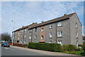
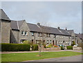
2
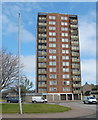
Kincorth Land, Tollohill Square, Kincorth
Kincorth has just one tower block, and this for your Geograph viewing pleasure is it: the recently refurbished Kincorth Land with 13 floors and 52 flats. Tollohill Square is in the foreground.
Image: © Bill Harrison
Taken: 19 Apr 2014
0.09 miles
4
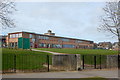
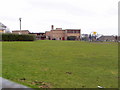
Kirkhill Primary School, Kincorth, Aberdeen
Image: © Bill Harrison
Taken: 19 Apr 2014
0.13 miles
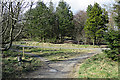
5
Fallen trees on Kincorth Hill
Fallen trees blocking the path up Kincorth Hill.
Image: © Scott Cormie
Taken: 21 May 2022
0.14 miles
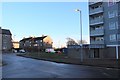
6
Granite block, Provost Watt Drive, Kincorth
Many of the main avenues into Aberdeen's council estates are named after Lord Provosts (see: http://en.wikipedia.org/wiki/Lord_Provost ). Edward Watt was Lord Provost from 1935 to 1938 when the Kincorth estate was being laid out.
Image: © Bill Harrison
Taken: 19 Apr 2014
0.15 miles
7
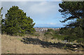
View from Kincorth Hill
A gap in the woods offers a view towards the sea and to the offshore wind turbines.
Image: © Anne Burgess
Taken: 20 Mar 2020
0.16 miles
8
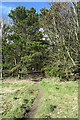
Informal Path
The passage of many feet has created an informal path linking the main paved paths.
Image: © Anne Burgess
Taken: 20 Mar 2020
0.17 miles
9
Granite block, Arbroath Road, Kincorth
Image: © Bill Harrison
Taken: 19 Apr 2014
0.17 miles
10
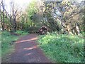
Path Junction
There is a good network of paths in Kincorth Hill local nature reserve, of which this is probably the most complicated.
Image: © Anne Burgess
Taken: 20 Mar 2020
0.18 miles