IMAGES TAKEN NEAR TO
Corthan Crescent, ABERDEEN, AB12 5BA
Introduction
This page details the photographs taken nearby to Corthan Crescent, AB12 5BA by members of the Geograph project.
The Geograph project started in 2005 with the aim of publishing, organising and preserving representative images for every square kilometre of Great Britain, Ireland and the Isle of Man.

There are currently over 7.5m images from over14,400 individuals and you can help contribute to the project by visiting https://www.geograph.org.uk
Image Map
Images are licensed for reuse under creativecommons.org/licenses/by-sa/2.0
Notes
- Clicking on the map will re-center to the selected point.
- The higher the marker number, the further away the image location is from the centre of the postcode.
Image Listing (13 Images Found)
Images are licensed for reuse under creativecommons.org/licenses/by-sa/2.0
Image
Details
Distance
1
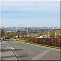
Abbotswell Crescent, Kincorth
The view towards Aberdeen: just visible to the right of the streetlamp in the middle of the picture is the McGrigor obelisk in Duthie Park and beyond that is the Talisman Energy office block, with its "aircraft carrier" roof.
Image: © Bill Harrison
Taken: 19 Apr 2014
0.11 miles
3
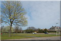
Provost Watt Drive, Kincorth
The main road into the estate, with lavish amounts of green space either side.
Image: © Bill Harrison
Taken: 19 Apr 2014
0.13 miles
4
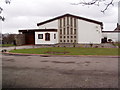
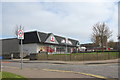
Our Lady of Aberdeen RC Church, Kincorth
Image: © Bill Harrison
Taken: 19 Apr 2014
0.13 miles
5
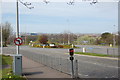
Abbot's Place roundabout, Kincorth
The left-turn has been blocked except for cycles.
Image: © Bill Harrison
Taken: 19 Apr 2014
0.14 miles
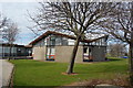
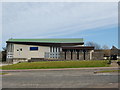
9
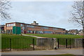
Kirkhill Primary School, Kincorth, Aberdeen
Image: © Bill Harrison
Taken: 19 Apr 2014
0.19 miles
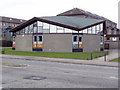
10
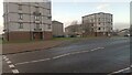
Cubic Blocks, Provost Watt Drive
There are three of these stand-alone blocks - which have a certain functional charm about them - towards the top of the wide and windy road that runs through the Kincorth housing estate. Each block houses nine flats; presumably this means there is one on the ground floor and two on all the upper ones.
Aberdeen Council held a public competition for the design of the current estate as long ago as 1937. Slightly bizarrely, the winners were from Pall Mall, London, and received £500 for their efforts. The war held things up a bit, but once it was over building began, and over time the design was increasingly ignored: it was originally all meant to be houses.
Amateurs like myself would probably assume that this suburb of Aberdeen, just South of the River Dee, took its name from a farm shown on old OS maps which was located at the SouthEast of today's estate, on the West Tullos Road (B985).
Thankfully, however, there is a very well-written short pdf guide to the area freely available online by a George McKnight. It turns out the name has been around for centuries and that its area was once far more extensive. Several maps exist from the 18th Century and earlier, perhaps because of the various land disputes mentioned in the guide. Covenanter forces gathered here in 1639 in the early days of the arguments about the monarchy and religion - before it all got a bit messy and confusing - prior to heading into battle with the Aberdeen forces, who were still loyal to Charles I at the time. The Kincorth campers won.
Image: © Ian Dodds
Taken: 26 Nov 2022
0.21 miles