IMAGES TAKEN NEAR TO
Lochinch Avenue, ABERDEEN, AB12 3SF
Introduction
This page details the photographs taken nearby to Lochinch Avenue, AB12 3SF by members of the Geograph project.
The Geograph project started in 2005 with the aim of publishing, organising and preserving representative images for every square kilometre of Great Britain, Ireland and the Isle of Man.

There are currently over 7.5m images from over14,400 individuals and you can help contribute to the project by visiting https://www.geograph.org.uk
Image Map
Images are licensed for reuse under creativecommons.org/licenses/by-sa/2.0
Notes
- Clicking on the map will re-center to the selected point.
- The higher the marker number, the further away the image location is from the centre of the postcode.
Image Listing (6 Images Found)
Images are licensed for reuse under creativecommons.org/licenses/by-sa/2.0
Image
Details
Distance
1
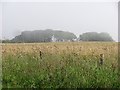
Barley, Rigifa
A field which has so far resisted the spread of Aberdeen.
Haar is returning after a brief sunny spell.
Image: © Richard Webb
Taken: 3 Aug 2011
0.13 miles
2
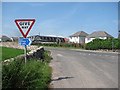
National Cycle Network sign
A road junction on the current edge of Cove, which is rapidly expanding.
Image: © Richard Webb
Taken: 3 Aug 2011
0.13 miles
3
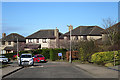
Charlestown Circle
One of the slightly maturer streets in Charlestown.
Image: © Anne Burgess
Taken: 20 Mar 2020
0.17 miles
4
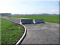
Blocked road, Cove
Access road for office/industrial buildings which are yet to be built. Aberdeen is still expanding.
Image: © Richard Webb
Taken: 3 Aug 2011
0.20 miles
5
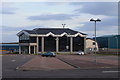
Charleston Primary School
For the school website, see: http://www.charleston.aberdeen.sch.uk/ .
Image: © Bill Harrison
Taken: 16 Jun 2013
0.24 miles
6
New office complex at Covebay
New office complex at Rigifa Farm, Covebay
Image: © Colin Kinnear
Taken: 19 Mar 2011
0.24 miles