IMAGES TAKEN NEAR TO
Lochinch Way, ABERDEEN, AB12 3QQ
Introduction
This page details the photographs taken nearby to Lochinch Way, AB12 3QQ by members of the Geograph project.
The Geograph project started in 2005 with the aim of publishing, organising and preserving representative images for every square kilometre of Great Britain, Ireland and the Isle of Man.

There are currently over 7.5m images from over14,400 individuals and you can help contribute to the project by visiting https://www.geograph.org.uk
Image Map
Images are licensed for reuse under creativecommons.org/licenses/by-sa/2.0
Notes
- Clicking on the map will re-center to the selected point.
- The higher the marker number, the further away the image location is from the centre of the postcode.
Image Listing (4 Images Found)
Images are licensed for reuse under creativecommons.org/licenses/by-sa/2.0
Image
Details
Distance
1
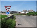
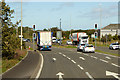
National Cycle Network sign
A road junction on the current edge of Cove, which is rapidly expanding.
Image: © Richard Webb
Taken: 3 Aug 2011
0.11 miles
2
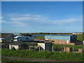
Small businesses
Small businesses adjacent to the Charleston intersection of the A90 and A956 with Loirston Loch in the background.
Image: © Lizzie
Taken: 21 May 2005
0.20 miles
3
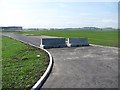
Blocked road, Cove
Access road for office/industrial buildings which are yet to be built. Aberdeen is still expanding.
Image: © Richard Webb
Taken: 3 Aug 2011
0.22 miles