IMAGES TAKEN NEAR TO
Nigg, ABERDEEN, AB12 3LL
Introduction
This page details the photographs taken nearby to AB12 3LL by members of the Geograph project.
The Geograph project started in 2005 with the aim of publishing, organising and preserving representative images for every square kilometre of Great Britain, Ireland and the Isle of Man.

There are currently over 7.5m images from over14,400 individuals and you can help contribute to the project by visiting https://www.geograph.org.uk
Image Map
Images are licensed for reuse under creativecommons.org/licenses/by-sa/2.0
Notes
- Clicking on the map will re-center to the selected point.
- The higher the marker number, the further away the image location is from the centre of the postcode.
Image Listing (8 Images Found)
Images are licensed for reuse under creativecommons.org/licenses/by-sa/2.0
Image
Details
Distance
1
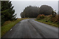
The old road south from Aberdeen
This was once part of the main trunk road running south from Aberdeen. It is now used only by local traffic.
Image: © Nigel Corby
Taken: 25 Sep 2019
0.05 miles
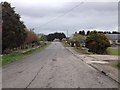
3
A90 from Charleston flyover
Taken looking north from the flyover at Charleston with Aberdeen in the distance. This is the main routeway into Aberdeen from the South.
Image: © Lizzie
Taken: 5 Jun 2005
0.15 miles
4
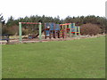
Children's playpark at Interpretation Centre
Image: © Ewen Rennie
Taken: 28 Feb 2010
0.18 miles
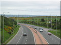
5
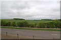
Fields from the Aberdeen ring road near Charlestown
Image: © Mike Pennington
Taken: 29 May 2017
0.19 miles
6
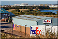
FedEx, Aberdeen
The FedEx depot at Charlestown in Aberdeen
Image: © Nigel Corby
Taken: 21 Sep 2019
0.20 miles
7
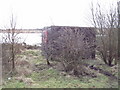
Another hide
Can you see the three swans on the Loch?
Image: © Ewen Rennie
Taken: 28 Feb 2010
0.23 miles
8
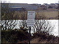
Fish limited here.
I think the lower sign is in Polish. There are a lot of Eastern Europeans living in nearby Torry now.
Image: © Ewen Rennie
Taken: 28 Feb 2010
0.24 miles