IMAGES TAKEN NEAR TO
Peterseat Drive, ABERDEEN, AB12 3HT
Introduction
This page details the photographs taken nearby to Peterseat Drive, AB12 3HT by members of the Geograph project.
The Geograph project started in 2005 with the aim of publishing, organising and preserving representative images for every square kilometre of Great Britain, Ireland and the Isle of Man.

There are currently over 7.5m images from over14,400 individuals and you can help contribute to the project by visiting https://www.geograph.org.uk
Image Map
Images are licensed for reuse under creativecommons.org/licenses/by-sa/2.0
Notes
- Clicking on the map will re-center to the selected point.
- The higher the marker number, the further away the image location is from the centre of the postcode.
Image Listing (6 Images Found)
Images are licensed for reuse under creativecommons.org/licenses/by-sa/2.0
Image
Details
Distance
1
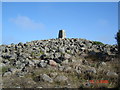
Baron's Cairn on Tullos Hill
Baron's Cairn with the Ordnance Survey Trig. point on the top.
The highest point on Tullos Hill.
Image: © George Wilson
Taken: 19 Aug 2006
0.17 miles
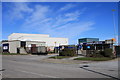
2
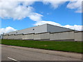
ASCO Building, Altens Industrial Estate
The building is completely anonymous: for the company website, see: http://www.ascoworld.com/Default.aspx?tabid=83 .
Image: © Bill Harrison
Taken: 18 Aug 2013
0.17 miles
3
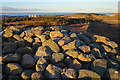
View from Cat Cairn
The long dyke, flanked by a good path, runs from Cat Cairn to Baron's Cairn at the highest point of Tullos Hill, where there is also a trig point.
Image: © Anne Burgess
Taken: 9 Mar 2018
0.19 miles
4
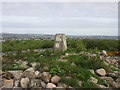
Baron's Cairn trig pillar
The triangulation pillar on Baron's Cairn, looking towards Aberdeen.
Image: © Scott Cormie
Taken: 25 May 2019
0.19 miles
5

Baron's Cairn...
...at the top of Tullos Hill: https://canmore.org.uk/site/20242/barons-cairn-tullos-hill . Girdleness Lighthouse is just visible in the distance.
Image: © Bill Harrison
Taken: 16 Apr 2016
0.19 miles
6
Altens industrial estate
Commercial buildings on Altens industrial estate.
Image: © Colin Kinnear
Taken: 18 Mar 2011
0.22 miles