IMAGES TAKEN NEAR TO
Charleston Road, ABERDEEN, AB12 3FH
Introduction
This page details the photographs taken nearby to Charleston Road, AB12 3FH by members of the Geograph project.
The Geograph project started in 2005 with the aim of publishing, organising and preserving representative images for every square kilometre of Great Britain, Ireland and the Isle of Man.

There are currently over 7.5m images from over14,400 individuals and you can help contribute to the project by visiting https://www.geograph.org.uk
Image Map
Images are licensed for reuse under creativecommons.org/licenses/by-sa/2.0
Notes
- Clicking on the map will re-center to the selected point.
- The higher the marker number, the further away the image location is from the centre of the postcode.
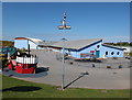
Image Listing (5 Images Found)
Images are licensed for reuse under creativecommons.org/licenses/by-sa/2.0
Image
Details
Distance
1
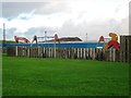
Charleston Primary School
For the school website, see: http://www.charleston.aberdeen.sch.uk/ .
Image: © Bill Harrison
Taken: 16 Jun 2013
0.02 miles

3
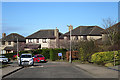
Charlestown Circle
One of the slightly maturer streets in Charlestown.
Image: © Anne Burgess
Taken: 20 Mar 2020
0.11 miles
4
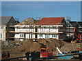
New housing at Cove
The settlement of Cove is growing apace into the open land to the south west of the current settlement. Many new family houses are being built in this area. It is popular as it is less expensive than many other areas of Aberdeen.
Image: © Lizzie
Taken: 21 May 2005
0.11 miles