IMAGES TAKEN NEAR TO
Craigshaw Drive, ABERDEEN, AB12 3AN
Introduction
This page details the photographs taken nearby to Craigshaw Drive, AB12 3AN by members of the Geograph project.
The Geograph project started in 2005 with the aim of publishing, organising and preserving representative images for every square kilometre of Great Britain, Ireland and the Isle of Man.

There are currently over 7.5m images from over14,400 individuals and you can help contribute to the project by visiting https://www.geograph.org.uk
Image Map
Images are licensed for reuse under creativecommons.org/licenses/by-sa/2.0
Notes
- Clicking on the map will re-center to the selected point.
- The higher the marker number, the further away the image location is from the centre of the postcode.
Image Listing (19 Images Found)
Images are licensed for reuse under creativecommons.org/licenses/by-sa/2.0
Image
Details
Distance
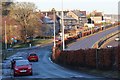
2
Granite block, Arbroath Road, Kincorth
Image: © Bill Harrison
Taken: 19 Apr 2014
0.12 miles
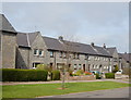
3
Abbotswell Crescent
Abbotswell Crescent on the southern edge of Aberdeen, looking north-westwards.
Image: © Scott Cormie
Taken: 21 May 2022
0.13 miles
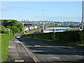
4
Nigg Kirk Road
Modern blocks of flats in a curving street that takes its name from the nearby Image
Image: © Anne Burgess
Taken: 20 Mar 2020
0.15 miles
5
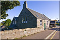
Nigg church hall, (converted)
Now in use as a veterinary practice.
Image: © Alan Findlay
Taken: 8 Sep 2011
0.19 miles
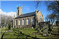
7
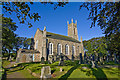
Nigg Kirk
Nigg Kirk was built in 1829 to the design of John Smith to replace the (now ruined) St Fittick's Kirk in Torry. Compare St Clement's Church: http://www.geograph.org.uk/photo/3378773 . As already pointed out by Peter Robinson (http://www.geograph.org.uk/photo/3065186 ), the windows are fakes, presumably on top of the boarded-up originals.
Image: © Bill Harrison
Taken: 16 Apr 2016
0.20 miles
8
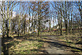
Kincorth Hill
Kincorth Hill, named as Stoney Hill on older maps, is now a local nature reserve. This is just inside the east end of the reserve, off West Tullos Road.
Image: © Anne Burgess
Taken: 20 Mar 2020
0.20 miles
9
Nigg Parish Kirk
This kirk and was built in 1828-1829 and replaced Image A new turnpike road to Stonehaven, now Wellington Road, had recently been built, and the new kirk was sited here in the expectation that the population of the parish would shift towards the new road. The architect was Aberdeen-born John Smith (1781-1852). It is a Category B listed building, but is no longer in ecclesiastical use.
Image: © Anne Burgess
Taken: 20 Mar 2020
0.20 miles
10
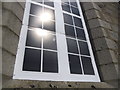
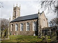
Windows on Nigg Kirk
Another one of Aberdeen's many empty churches
Image: © Peter Robinson
Taken: 3 Aug 2012
0.20 miles