IMAGES TAKEN NEAR TO
Abbotswell Road, ABERDEEN, AB12 3AJ
Introduction
This page details the photographs taken nearby to Abbotswell Road, AB12 3AJ by members of the Geograph project.
The Geograph project started in 2005 with the aim of publishing, organising and preserving representative images for every square kilometre of Great Britain, Ireland and the Isle of Man.

There are currently over 7.5m images from over14,400 individuals and you can help contribute to the project by visiting https://www.geograph.org.uk
Image Map
Images are licensed for reuse under creativecommons.org/licenses/by-sa/2.0
Notes
- Clicking on the map will re-center to the selected point.
- The higher the marker number, the further away the image location is from the centre of the postcode.
Image Listing (6 Images Found)
Images are licensed for reuse under creativecommons.org/licenses/by-sa/2.0
Image
Details
Distance
1
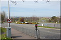
Abbot's Place roundabout, Kincorth
The left-turn has been blocked except for cycles.
Image: © Bill Harrison
Taken: 19 Apr 2014
0.03 miles
2
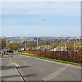
Abbotswell Crescent, Kincorth
The view towards Aberdeen: just visible to the right of the streetlamp in the middle of the picture is the McGrigor obelisk in Duthie Park and beyond that is the Talisman Energy office block, with its "aircraft carrier" roof.
Image: © Bill Harrison
Taken: 19 Apr 2014
0.09 miles
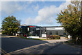
3
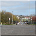
Abbotswell Road, Aberdeen
Note the unusual road signs prohibiting parking on the pavement.
Image: © Bill Harrison
Taken: 19 Apr 2014
0.13 miles
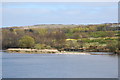
4
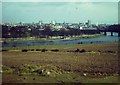
River Dee from Kincorth
View across the Dee, looking towards the Duthie Park with the city centre on the skyline.
http://en.wikipedia.org/wiki/Aberdeen
Image: © Colin Smith
Taken: Unknown
0.20 miles
6
Shoal on the River Dee
The setting in the middle of Aberdeen looks deceptively rural...
Image: © Bill Harrison
Taken: 19 Apr 2014
0.25 miles