IMAGES TAKEN NEAR TO
Sinclair Road, ABERDEEN, AB11 9PR
Introduction
This page details the photographs taken nearby to Sinclair Road, AB11 9PR by members of the Geograph project.
The Geograph project started in 2005 with the aim of publishing, organising and preserving representative images for every square kilometre of Great Britain, Ireland and the Isle of Man.

There are currently over 7.5m images from over14,400 individuals and you can help contribute to the project by visiting https://www.geograph.org.uk
Image Map
Images are licensed for reuse under creativecommons.org/licenses/by-sa/2.0
Notes
- Clicking on the map will re-center to the selected point.
- The higher the marker number, the further away the image location is from the centre of the postcode.
Image Listing (87 Images Found)
Images are licensed for reuse under creativecommons.org/licenses/by-sa/2.0
Image
Details
Distance
1
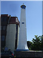
Leading Light on Sinclair Road
Westward of two leading lights for Aberdeen Harbour entrance.
Image: © JThomas
Taken: 18 Jul 2014
0.01 miles
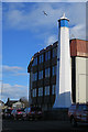
2
Leading Light on Sinclair Road
Westward of two leading lights for Aberdeen Harbour.
Image: © JThomas
Taken: 18 Jul 2014
0.01 miles
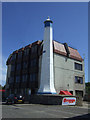
3
West Leading Light
The leading lights were erected in 1842. A ship approaching the harbour steers until the two lights appear one above the other, and as long as it maintains that course it is guided into the safe channel. I imagine that they are now no longer required, with all the navigational technology now available. Image]
Image: © Anne Burgess
Taken: 9 Mar 2018
0.01 miles
4
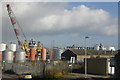
Harbourside activity, Torry
The fishing boats are long gone but there is intense activity in terms of North Sea oil.
Image: © Bill Harrison
Taken: 24 Sep 2011
0.05 miles
5
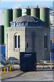
Syphon House
The little octagonal granite building is one of two syphon houses built in 1906 as part of the system for discharging sewage from north of the river to the outfall at Girdle Ness. The other is at Point Law on the other side of the channel. Unfortunately it is in a locked-off area and I couldn't find an angle to photograph it without the container in front.
Image: © Anne Burgess
Taken: 9 Mar 2018
0.07 miles
6
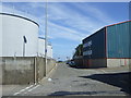
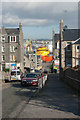
National Cycle Route 1
Sinclair Road heading east.
Image: © JThomas
Taken: 18 Jul 2014
0.07 miles
8
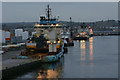
Docked in Aberdeen
Two large oil support vessels docked in Aberdeen harbour. The 'Edda Frende' is a new design of PSV (ST-216) on contract to Shell. See http://www.skipsteknisk.no/default.asp?menu=4&id=112
Image: © Colin Kinnear
Taken: 3 Feb 2011
0.10 miles
9
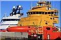
Looking down Mansfield Road, Torry
This road is steep enough to merit handrails for predetrians. An oil service vessel in typical vivid colours is moored at Torry dock.
Image: © Bill Harrison
Taken: 24 Sep 2011
0.10 miles
10
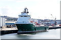
Havila Aurora at Torry Quay, Aberdeen
Image: © Mike Pennington
Taken: 2 Jun 2017
0.11 miles