IMAGES TAKEN NEAR TO
Victoria Road, ABERDEEN, AB11 9NT
Introduction
This page details the photographs taken nearby to Victoria Road, AB11 9NT by members of the Geograph project.
The Geograph project started in 2005 with the aim of publishing, organising and preserving representative images for every square kilometre of Great Britain, Ireland and the Isle of Man.

There are currently over 7.5m images from over14,400 individuals and you can help contribute to the project by visiting https://www.geograph.org.uk
Image Map
Images are licensed for reuse under creativecommons.org/licenses/by-sa/2.0
Notes
- Clicking on the map will re-center to the selected point.
- The higher the marker number, the further away the image location is from the centre of the postcode.
Image Listing (50 Images Found)
Images are licensed for reuse under creativecommons.org/licenses/by-sa/2.0
Image
Details
Distance
1
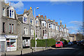
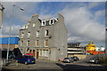
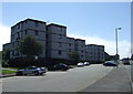
Victoria Road
This is the main street in 'New Torry', the expansion of which began with the construction of the Victoria Bridge in 1881. Victoria Street and the adjacent streets are lined with silver-grey granite tenements and villas.
Image: © Anne Burgess
Taken: 9 Mar 2018
0.09 miles
2
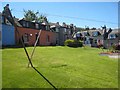
Old cottages in Torry
The best preserved of the few squares of fishermen's cottages still remaining in Torry. Much of the old fishing village was torn down to make way for new port installations during the oil boom.
Image: © Oliver Dixon
Taken: 25 May 2008
0.10 miles
3
Leading Light on Sinclair Road
Westward of two leading lights for Aberdeen Harbour entrance.
Image: © JThomas
Taken: 18 Jul 2014
0.11 miles
4
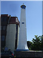
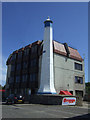
West Leading Light
The leading lights were erected in 1842. A ship approaching the harbour steers until the two lights appear one above the other, and as long as it maintains that course it is guided into the safe channel. I imagine that they are now no longer required, with all the navigational technology now available. Image]
Image: © Anne Burgess
Taken: 9 Mar 2018
0.12 miles
5
Leading Light on Sinclair Road
Westward of two leading lights for Aberdeen Harbour.
Image: © JThomas
Taken: 18 Jul 2014
0.13 miles
6
Granite block, Crombie Road, Torry
Mansfield Road visible in the foreground.
Image: © Bill Harrison
Taken: 24 Sep 2011
0.13 miles
7
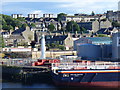
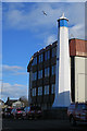
Leading Light and Torry
The eastern leading light seen here is one of two lights which, when aligned by line of sight, guide ships through the Aberdeen harbour channel. In front of the light is the oil support vessel, "Highland Prestige". Behind the light are houses along Sinclair Road, Abbey Road and Victoria Road in Torry.
Image: © Colin Smith
Taken: 9 Jul 2010
0.15 miles
8
National Cycle Route 1
Sinclair Road heading east.
Image: © JThomas
Taken: 18 Jul 2014
0.15 miles
10
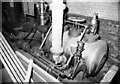
Victoria Saw Mills, steam engine
Owned by James Cordiner & Son Ltd and situated at 100 Sinclair road, Aberdeen. Horizontal single cylinder drop valve engine by Marshall Sons & Co Ltd, Gainsborough. No. 48835 of 1908. Flywheel 12' diameter and driving by ropes (seen bottom left). About 150 horsepower. In use until 1975 and on standby until the late 1970s. Scrapped in 1983 or 4. The steam valves had trip gear controlled by the Proell governor and the exhaust valves were operated by cams with roller followers.
Image: © Chris Allen
Taken: 6 May 1982
0.16 miles