IMAGES TAKEN NEAR TO
Farquhar Road, ABERDEEN, AB11 8SE
Introduction
This page details the photographs taken nearby to Farquhar Road, AB11 8SE by members of the Geograph project.
The Geograph project started in 2005 with the aim of publishing, organising and preserving representative images for every square kilometre of Great Britain, Ireland and the Isle of Man.

There are currently over 7.5m images from over14,400 individuals and you can help contribute to the project by visiting https://www.geograph.org.uk
Image Map
Images are licensed for reuse under creativecommons.org/licenses/by-sa/2.0
Notes
- Clicking on the map will re-center to the selected point.
- The higher the marker number, the further away the image location is from the centre of the postcode.
Image Listing (15 Images Found)
Images are licensed for reuse under creativecommons.org/licenses/by-sa/2.0
Image
Details
Distance
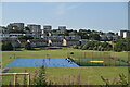
1
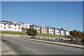
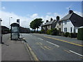
Hillside housing, Girdleness Road, Aberdeen
Torry is built on a hill, and a number of south-facing blocks of flats rise up in tiers...
Image: © Bill Harrison
Taken: 6 Oct 2012
0.05 miles
2
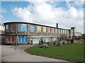
Tullos Primary School
The classroom blinds add a nice bit of colour to this iconic 1930s art deco building, but the rusting metal and crumbling mortar are concerning... B-listed: http://www.britishlistedbuildings.co.uk/sc-49995-tullos-primary-school-girdleness-road-#.VxNisaT2amQ .
Image: © Bill Harrison
Taken: 16 Apr 2016
0.08 miles
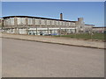
3
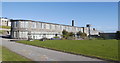
Tullos Primary School
One of Aberdeen's most striking 1930s buildings (although it did not open until 1950). It was meant to have a pitched roof, but the War intervened and a flat roof was installed. Its south-facing and light and airy construction, with "fold back" glazed panels (now sadly no longer functional) must have been truly ground-breaking.
B-listed: http://www.britishlistedbuildings.co.uk/sc-49995-tullos-primary-school-girdleness-road-
Image: © Bill Harrison
Taken: 6 Oct 2012
0.09 miles
8
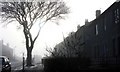
Early morning sea haar in Torry housing estate.
On the east coast of Scotland a sea fog, known locally as Haar, often plagues the local residents and ruins what would otherwise be a fine day. It most commonly occurs between April and September, on or near the east coast or in the Northern Isles.
It does not usually penetrate far inland, but can filter through valleys like the Great Glen and the Central Lowlands as far as Glasgow. Haar forms when a parcel of warm air passes over the cold North Sea. The warm air at the bottom of the parcel is cooled by the cold air below, until it can no longer 'hold' the moisture that was previously contained within. Therefore, it releases some of the moisture in the form of liquid water through condensation. Add an onshore component like a wind of 5-20mph, and the cooling in the bottom of the warm parcel of air is spread upwards and generates a fog like Haar.
Image: © Colin Kinnear
Taken: 3 Feb 2011
0.15 miles
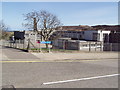
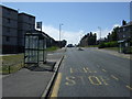
10
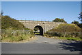
Under the Bridge
Motor vehicles are now blocked from Ladywell Place (under the bridge). The bridge carries the main Aberdeen-Dundee railway line.
Image: © Bill Harrison
Taken: 6 Oct 2012
0.18 miles