IMAGES TAKEN NEAR TO
Girdleness Road, ABERDEEN, AB11 8DT

Introduction

This page details the photographs taken nearby to Girdleness Road, AB11 8DT by members of the Geograph project.

The Geograph project started in 2005 with the aim of publishing, organising and preserving representative images for every square kilometre of Great Britain, Ireland and the Isle of Man.

There are currently over 7.5m images from over14,400 individuals and you can help contribute to the project by visiting https://www.geograph.org.uk

Image Map


Images are licensed for reuse under creativecommons.org/licenses/by-sa/2.0
Notes
  • Clicking on the map will re-center to the selected point.
  • The higher the marker number, the further away the image location is from the centre of the postcode.

Image Listing (19 Images Found)

Images are licensed for reuse under creativecommons.org/licenses/by-sa/2.0
Image
Details
Distance
1
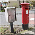
Edward VIII pillar box...
...at the junction of Gregness Gardens and Girdleness Road. One of only two to be found in Aberdeen and 136 nationwide.
Image: © Bill Harrison Taken: 16 Apr 2016
0.08 miles
2
Gregness Gardens, Aberdeen
The unusual "X" shaped junction that connects the parallel roads of Girdleness Road and Kirkhill Road.
Image: © Bill Harrison Taken: 6 Oct 2012
0.09 miles
3
Railside industry
Image: © N Chadwick Taken: 29 Jul 2022
0.11 miles
4
Balnagask Road
The junction with Oscar Road to the left. Ungainly 20th century council housing.
Image: © Anne Burgess Taken: 9 Mar 2018
0.11 miles
5
Part of Craiginches freight terminal, Aberdeen
Blue Circle terminal on the north side of the track. Taken from a passing train heading into Aberdeen.
Image: © Carl Farnell Taken: 11 Dec 2006
0.12 miles
6
Shops on Balnagask Road
Image: © JThomas Taken: 18 Jul 2014
0.13 miles
7
Trackside park
Image: © N Chadwick Taken: 29 Jul 2022
0.14 miles
8
Suburban flats...
...at the junction of Old Church Road and Girdleness Road.
Image: © Bill Harrison Taken: 6 Oct 2012
0.14 miles
9
Railway Line
This is the main rail line south from Aberdeen. Tullos Industrial Estate is on the right, with Tullos Hill beyond.
Image: © Anne Burgess Taken: 9 Mar 2018
0.19 miles
10
Torry Academy
The original school building on the left with the 1970's addition on the right with the funny roof.
Image: © Ewen Rennie Taken: 2 Apr 2010
0.19 miles