IMAGES TAKEN NEAR TO
Old Church Road, ABERDEEN, AB11 8DF
Introduction
This page details the photographs taken nearby to Old Church Road, AB11 8DF by members of the Geograph project.
The Geograph project started in 2005 with the aim of publishing, organising and preserving representative images for every square kilometre of Great Britain, Ireland and the Isle of Man.

There are currently over 7.5m images from over14,400 individuals and you can help contribute to the project by visiting https://www.geograph.org.uk
Image Map
Images are licensed for reuse under creativecommons.org/licenses/by-sa/2.0
Notes
- Clicking on the map will re-center to the selected point.
- The higher the marker number, the further away the image location is from the centre of the postcode.
Image Listing (30 Images Found)
Images are licensed for reuse under creativecommons.org/licenses/by-sa/2.0
Image
Details
Distance
2
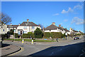
Balnagask Road
The junction with Oscar Road to the left. Ungainly 20th century council housing.
Image: © Anne Burgess
Taken: 9 Mar 2018
0.04 miles
3
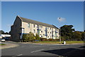
Suburban flats...
...at the junction of Old Church Road and Girdleness Road.
Image: © Bill Harrison
Taken: 6 Oct 2012
0.04 miles
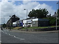
5
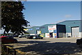
Industrial units, Girdleness Road, Aberdeen
Image: © Bill Harrison
Taken: 6 Oct 2012
0.12 miles
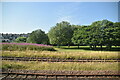
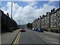
10
Railway Line
This is the main rail line south from Aberdeen. Tullos Industrial Estate is on the right, with Tullos Hill beyond.
Image: © Anne Burgess
Taken: 9 Mar 2018
0.17 miles