IMAGES TAKEN NEAR TO
Hardgate, ABERDEEN, AB11 6XA
Introduction
This page details the photographs taken nearby to Hardgate, AB11 6XA by members of the Geograph project.
The Geograph project started in 2005 with the aim of publishing, organising and preserving representative images for every square kilometre of Great Britain, Ireland and the Isle of Man.

There are currently over 7.5m images from over14,400 individuals and you can help contribute to the project by visiting https://www.geograph.org.uk
Image Map
Images are licensed for reuse under creativecommons.org/licenses/by-sa/2.0
Notes
- Clicking on the map will re-center to the selected point.
- The higher the marker number, the further away the image location is from the centre of the postcode.
Image Listing (194 Images Found)
Images are licensed for reuse under creativecommons.org/licenses/by-sa/2.0
Image
Details
Distance
1
Union Glen
The site of the Aberdeen March stone Number 1
The inner march stones mark the boundary of the crofts that ringed the medieval Royal Burgh of Aberdeen. The outer march stones define a much larger area known as the Freedom Lands. These lands went on to become the right and responsibility of the medieval and later Royal Burgh of Aberdeen. The name 'march stones' derives from the 16th century meaning of march as a boundary. Although the march stones of Aberdeen are easy to access, many are difficult to get to.
Image: © Ralph Greig
Taken: 1 Jun 2023
0.02 miles
2
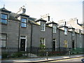
Granite houses in Ferryhill
Just outwith the CBD, Ferryhill has a wide variety of granite housing.
Image: © Lizzie
Taken: 14 May 2005
0.02 miles
3
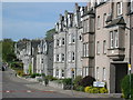
Modern buildings in traditional style
Modern property built in traditional style in Ferryhill, just outwith the CBD of Aberdeen
Image: © Lizzie
Taken: 14 May 2005
0.02 miles
4
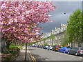
Cherry Blossom in the West End of Aberdeen
Image: © Richard Slessor
Taken: 7 May 2005
0.02 miles
5
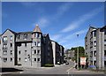
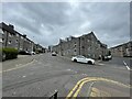
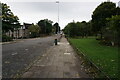
Looking up Hardgate
Hardgate means 'hard (metalled) road' according to Aberdeen Street Names by G. M. Fraser. The modern apartment blocks pay tribute to Aberdeen granite with their colour and detailing.
Image: © Bill Harrison
Taken: 12 Jul 2020
0.05 miles
7
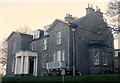
Willowbank House, Willowbank Road, Aberdeen
A late-18th Century villa modified by John Smith and B-listed: http://data.historic-scotland.gov.uk/pls/htmldb/f?p=2200:15:0::::BUILDING:20109 . It is now the "Aberdeen Business Centre."
Image: © Bill Harrison
Taken: 23 Nov 2014
0.06 miles
8
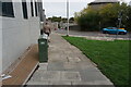
Turf Zone "Hardgate"
On Willowbank Road at Hardgate, Aberdeen.
Image: © Ian S
Taken: 5 Oct 2022
0.07 miles
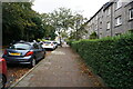
10
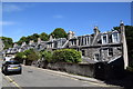
Urban cottages on Hardgate
The granite cottages date from ca. 1825 and are collectively C-listed (LB20203: http://portal.historicenvironment.scot/designation/LB20203 ).
Image: © Bill Harrison
Taken: 12 Jul 2020
0.07 miles