IMAGES TAKEN NEAR TO
Strawberry Bank Parade, ABERDEEN, AB11 6US
Introduction
This page details the photographs taken nearby to Strawberry Bank Parade, AB11 6US by members of the Geograph project.
The Geograph project started in 2005 with the aim of publishing, organising and preserving representative images for every square kilometre of Great Britain, Ireland and the Isle of Man.

There are currently over 7.5m images from over14,400 individuals and you can help contribute to the project by visiting https://www.geograph.org.uk
Image Map
Images are licensed for reuse under creativecommons.org/licenses/by-sa/2.0
Notes
- Clicking on the map will re-center to the selected point.
- The higher the marker number, the further away the image location is from the centre of the postcode.
Image Listing (250 Images Found)
Images are licensed for reuse under creativecommons.org/licenses/by-sa/2.0
Image
Details
Distance
1
Dwellings on Hardate
Dating from ca. 1825 with interesting windows spanning two storeys.
Image: © Bill Harrison
Taken: 12 Jul 2020
0.01 miles
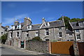
2
Urban cottages on Hardgate
The granite cottages date from ca. 1825 and are collectively C-listed (LB20203: http://portal.historicenvironment.scot/designation/LB20203 ).
Image: © Bill Harrison
Taken: 12 Jul 2020
0.03 miles
3
Hardgate cottages
Attractive dwellings approaching their 200th birthday and C-listed (LB20153: http://portal.historicenvironment.scot/designation/LB20153 ).
Image: © Bill Harrison
Taken: 12 Jul 2020
0.03 miles
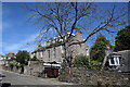
5
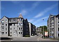
Looking up Hardgate
Hardgate means 'hard (metalled) road' according to Aberdeen Street Names by G. M. Fraser. The modern apartment blocks pay tribute to Aberdeen granite with their colour and detailing.
Image: © Bill Harrison
Taken: 12 Jul 2020
0.05 miles
6
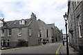
West Craibstone Street, Aberdeen
Terraces designed by Archibald Simpson; Bon Accord Square in the background.
Image: © Bill Harrison
Taken: 8 Jun 2014
0.05 miles
7
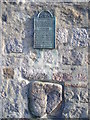
The Crabstane, Hardgate
This stone, about 1 foot square face, is set into the wall of a building on the south side of Aberdeen's former main road from the south. The plaque reads:
"The Crabstane. Boundary stone on lands belonging to John Crab, Baillie of the Burgh in 1314. The stone also marks the site of the skirmish in 1571 between the rival families of Gordon and Forbes and of an engagement in 1644 between the citizens of Aberdeen and the Royalist forces of the Marquis of Montrose".
Image: © Colin Smith
Taken: 24 Mar 2008
0.05 miles
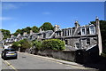
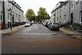
8
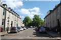
Bon Accord Terrace
Just 100 metres south of Union Street, the streets planned by Archibald Simpson in the 1820s almost have a village-like feel and there is very little traffic. The former church on Justice Mill Street in the background, which I have not managed to identify, is yet another nightclub conversion.
Image: © Bill Harrison
Taken: 1 Sep 2012
0.05 miles
9
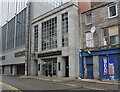
The Justice Mill Public House
A Wetherspoons pub on Union Street, Aberdeen. Taken from Justice Street.
Image: © Ian S
Taken: 4 Oct 2022
0.06 miles
10
West Crairstone Street off Bon Accord Crescent
Image: © Ian S
Taken: 5 Oct 2022
0.06 miles