IMAGES TAKEN NEAR TO
Regent Quay, ABERDEEN, AB11 5SS
Introduction
This page details the photographs taken nearby to Regent Quay, AB11 5SS by members of the Geograph project.
The Geograph project started in 2005 with the aim of publishing, organising and preserving representative images for every square kilometre of Great Britain, Ireland and the Isle of Man.

There are currently over 7.5m images from over14,400 individuals and you can help contribute to the project by visiting https://www.geograph.org.uk
Image Map
Images are licensed for reuse under creativecommons.org/licenses/by-sa/2.0
Notes
- Clicking on the map will re-center to the selected point.
- The higher the marker number, the further away the image location is from the centre of the postcode.
Image Listing (756 Images Found)
Images are licensed for reuse under creativecommons.org/licenses/by-sa/2.0
Image
Details
Distance
1
Aberdeen: reflections in the Harbour Office sign
The Northlink (Orkney and Shetland) ferry is recognisable as the harbour is reflected in the sign outside the Harbour Office.
Image: © Chris Downer
Taken: 6 Jul 2013
0.00 miles
2
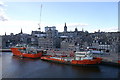
Aberdeen harbour
Splashes of red against the grey of the granite city.
Image: © Mike Pennington
Taken: 11 Apr 2009
0.01 miles
3
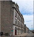
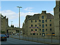
Harbour Board Offices, Regent Quay, Aberdeen
The B-listed block (14-16 Regent Quay) dates from ca. 1885: http://www.britishlistedbuildings.co.uk/sc-19986-14-15-and-16-regent-quay-harbour-offices- .
Image: © Bill Harrison
Taken: 12 May 2013
0.01 miles
5
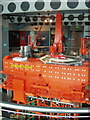
Oil platform model in Aberdeen Maritime Museum
This 8.5 metre high model soars up through three floors of the museum. The photo shows the platform itself at 3rd floor level. The top section started as a pipe clash model when the platform was designed. The orange facing has been added on this side, but on other sides the pipes and internal arrangement are visible. The curved pipe across the bottom of the photo is the handrail of the museum.
Image: © David Hawgood
Taken: 10 Sep 2007
0.02 miles
6
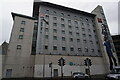
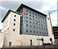
Ibis Hotel on Shiprow, Aberdeen
Taken from Regent Quay.
Image: © Ian S
Taken: 4 Oct 2022
0.03 miles
7
Virginia Street, Aberdeen
A dual carriageway road in the city centre, with Marischal Street crossing it on a bridge.
Image: © Stephen Craven
Taken: 1 Jul 2019
0.03 miles
8
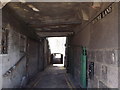
Aberdeen: Theatre Lane
An odd alleyway named after the fact that it passes along the back of the former Theatre Royal which was built in 1795. It closed in 1872, replaced by a theatre in Guild Street.
Image: © Chris Downer
Taken: 6 Jul 2013
0.04 miles
10
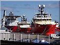
Oil Support Vessels
Red and white are the colours in Aberdeen's Upper Dock.
www.aberdeencity.gov.uk
Image: © Colin Smith
Taken: 5 Sep 2012
0.04 miles