IMAGES TAKEN NEAR TO
Stell Road, ABERDEEN, AB11 5QR
Introduction
This page details the photographs taken nearby to Stell Road, AB11 5QR by members of the Geograph project.
The Geograph project started in 2005 with the aim of publishing, organising and preserving representative images for every square kilometre of Great Britain, Ireland and the Isle of Man.

There are currently over 7.5m images from over14,400 individuals and you can help contribute to the project by visiting https://www.geograph.org.uk
Image Map
Images are licensed for reuse under creativecommons.org/licenses/by-sa/2.0
Notes
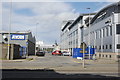
- Clicking on the map will re-center to the selected point.
- The higher the marker number, the further away the image location is from the centre of the postcode.
Image Listing (119 Images Found)
Images are licensed for reuse under creativecommons.org/licenses/by-sa/2.0
Image
Details
Distance
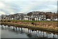
2
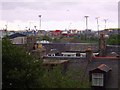
View from Ferryhill towards Torry
Ferryhill rooftops looking towards river Dee and Aberdeen harbour, servicing oil industry cargo ships. The entrance to Torry.
Image: © Colin Walker
Taken: 1 Jun 2005
0.06 miles
3
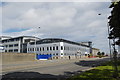
Bridge View office complex, North Esplanade West, Aberdeen
Image: © Bill Harrison
Taken: 1 Sep 2012
0.07 miles
4
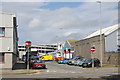
Raik Road, Aberdeen
Union Square multi-storey car park in the background.
Image: © Bill Harrison
Taken: 1 Sep 2012
0.07 miles
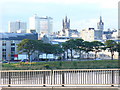
5
Aberdeen's North Esplanade
Looking across the River Dee towards North Esplanade West from Victoria Bridge, near Aberdeen harbour.
Image: © Mary and Angus Hogg
Taken: 28 Nov 2013
0.08 miles
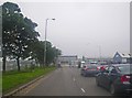
7
North Esplanade West
Riparian dualled trunk road which carries heavy goods traffic from the south into Aberdeen city centre. On the skyline are Porthill flats, St Nicholas House (since demolished), Mitchell Tower and the Town House.
Image: © Colin Smith
Taken: 11 Aug 2009
0.10 miles
8
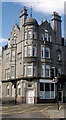
The Glory of Granite
The corner of Grimsby Chambers (built ca. 1905) at the junction of Market Street and Palmerston Road.
Image: © Bill Harrison
Taken: 1 Sep 2012
0.11 miles
9
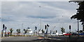
Junction of Market Street and North Esplanade
Count the traffic lights... Ships serving the offshore industry loom in the background...
Image: © Bill Harrison
Taken: 1 Sep 2012
0.12 miles
10
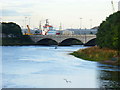
The Dee by Victoria Bridge
This tidal stretch of the Dee is used by several rowing clubs. In the background is the 5-arched Victoria Bridge which was built in 1881 to connect Aberdeen with Torry.
Image: © Colin Smith
Taken: 11 Aug 2009
0.12 miles