IMAGES TAKEN NEAR TO
Union Street, ABERDEEN, AB11 5BJ
Introduction
This page details the photographs taken nearby to Union Street, AB11 5BJ by members of the Geograph project.
The Geograph project started in 2005 with the aim of publishing, organising and preserving representative images for every square kilometre of Great Britain, Ireland and the Isle of Man.

There are currently over 7.5m images from over14,400 individuals and you can help contribute to the project by visiting https://www.geograph.org.uk
Image Map
Images are licensed for reuse under creativecommons.org/licenses/by-sa/2.0
Notes
- Clicking on the map will re-center to the selected point.
- The higher the marker number, the further away the image location is from the centre of the postcode.
Image Listing (953 Images Found)
Images are licensed for reuse under creativecommons.org/licenses/by-sa/2.0
Image
Details
Distance
1
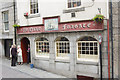
Ye Olde Frigate
A locals' bar... The sloping street leads to one of the rather mysterious "tunnels" that burrow under Union Street.
These "tunnels" follow former valleys leading down to the former course of the Dee at the harbour. Union Street itself is a 200 year old flyover, spanning several valleys between hilltops. The widest span is across the Denburn Valley - now occupied by Denburn Road, the railway line and Union Terrace Gardens.
Image: © Bill Harrison
Taken: 20 Jun 2008
0.01 miles
2
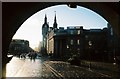
Aberdeen: Castlegate and Union Street
Looking down the Castlegate to Union Street from the Mercat Cross, just after the rain has stopped.
Image: © Chris Downer
Taken: 28 Oct 2006
0.01 miles
3
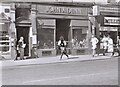
Chasing the 'monkey' down Union Street
An 'escaped monkey' is chased down the pavement of Union Street, Aberdeen by its 'keepers'. This was part of a publicity stunt to raise awareness of the Aberdeen Student Charities Campaign's latest fund-raising efforts.
They are passing John A Dunn Limited, a shoe shop at 46 Union Street. On the right is part of Millets Camping and Leisure.
Image: © Richard Sutcliffe
Taken: Unknown
0.01 miles
4
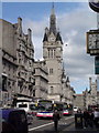
Union Street
View roughly eastwards with the towers of the Townhouse (left) and Salvation Army Citadel (right) visible in the distance.
Image: © Bill Harrison
Taken: 21 Sep 2013
0.02 miles
5
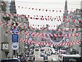
Aberdeen - A Sea of Red and White
Civic red and white bunting was put up along Union Street to celebrate the Dons reaching the Scottish Cup Final in 2017.
It outshadows the bunting for The Tour Series.
Image: © Colin Smith
Taken: 3 Jun 2017
0.02 miles
6
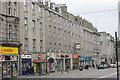
Union Street
Shops on Union Street, looking towards the traffic lights at the junction with Market Street.
Image: © Bill Harrison
Taken: 17 Jun 2008
0.02 miles
7
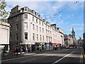
The glory of granite (Aberdeen style)
Buildings lining the north side of Union Street at its eastern end; Clydesdale Bank, various shops and commercial buildings and the massive tower of the town house. The road is designated the A9013, which according to the SABRE website, is the highest-numbered A-road in the UK: https://www.sabre-roads.org.uk/wiki/index.php?title=A9013 .
Image: © Bill Harrison
Taken: 12 Jul 2020
0.02 miles
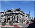
8
Union Street, Aberdeen
The tower is part of the Town House.
Image: © Mike Pennington
Taken: 8 May 2009
0.02 miles
9
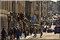
Union Street, City of Aberdeen
View along the length of the main street in Aberdeen, Scotland.
Image: © Andrew Tryon
Taken: 22 Aug 2019
0.02 miles