IMAGES TAKEN NEAR TO
Ruthrieston Terrace, ABERDEEN, AB10 7UG
Introduction
This page details the photographs taken nearby to Ruthrieston Terrace, AB10 7UG by members of the Geograph project.
The Geograph project started in 2005 with the aim of publishing, organising and preserving representative images for every square kilometre of Great Britain, Ireland and the Isle of Man.

There are currently over 7.5m images from over14,400 individuals and you can help contribute to the project by visiting https://www.geograph.org.uk
Image Map
Images are licensed for reuse under creativecommons.org/licenses/by-sa/2.0
Notes
- Clicking on the map will re-center to the selected point.
- The higher the marker number, the further away the image location is from the centre of the postcode.
Image Listing (82 Images Found)
Images are licensed for reuse under creativecommons.org/licenses/by-sa/2.0
Image
Details
Distance
1
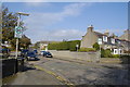
Ruthrieston Road, Aberdeen
The name might originate from "Ruadri's Town" (Ruadri was a 12th Century warlord/tribal chieftain). See: http://otheraberdeen.blogspot.com/2010/08/ruthrieston-pocket-park-revises-dark.html
Image: © Bill Harrison
Taken: 15 Oct 2011
0.03 miles
2
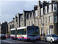
Aberdeen - Holburn Street
Granite tenements line the busy road at Ruthrieston, near Bridge of Dee. The bendy-bus is on the traditional No 1 "Bridges Route" between Dee and Don.
Image: © Colin Smith
Taken: 22 Mar 2008
0.07 miles
3
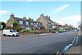
Holburn Street
The southern, suburban, end of Holburn Street near Bridge of Dee.
Image: © Anne Burgess
Taken: 17 Mar 2022
0.08 miles
4
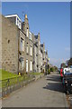
Granite block, Holburn Street, Aberdeen
Like many such blocks, rather disfigured by satellite dishes.
Image: © Bill Harrison
Taken: 15 Oct 2011
0.08 miles
5
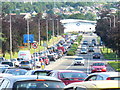
Evening Rush Hour on the Ring Road
Aberdeen traffic suffered through not having a modern ring road to take the strain off the 1930s ring road which has now been engulfed by the westward advance of new housing estates. The traffic here is queuing on South Anderson Drive. Ahead is the Bridge of Dee bottleneck.
The situation was alleviated by the construction of the Aberdeen Western Perimeter Road (AWPR) which was finally opened from 2018.
Image: © Colin Smith
Taken: 6 Aug 2009
0.08 miles
6
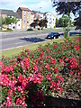
South Anderson Drive
A quiet moment on the normally busy ring road around Aberdeen's western suburbs. The flats are Headland Court, built on the site of the old Donald's ice rink which was later used by Sutherland's Haulage. The blooming roses help Aberdeen to win many annual "Britain in Bloom" competitions.
Image: © Colin Smith
Taken: 5 Aug 2009
0.10 miles
7
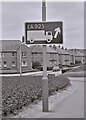
Road sign
A sign on the A92, South Anderson Drive, indicating lorries should bear right to continue south on the A92.
Image: © Richard Sutcliffe
Taken: Unknown
0.10 miles
8
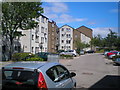
Headland Court
Development of flats, built in the 1980s.
Image: © Charlotte Lunn
Taken: 15 Jun 2011
0.10 miles
9
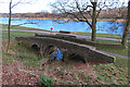
Ruthrieston Bridge
The hump-backed bridge over the Ruthrieston Burn was built in 1693, possibly succeeding an earlier bridge. It was moved 35 yards east in 1923, and re-erected. See http://portal.historicenvironment.scot/designation/LB20071 for details. The burn flows into the River Dee.
Image: © Anne Burgess
Taken: 17 Mar 2022
0.13 miles
10
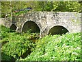
Aberdeen - Packhorse Bridge
Now a footbridge, this medieval structure once carried the main road south from Aberdeen to the Brig o'Dee.
www.aberdeencity.gov.uk
Image: © Colin Smith
Taken: 6 May 2014
0.13 miles