IMAGES TAKEN NEAR TO
Ramsay Crescent, ABERDEEN, AB10 7BN
Introduction
This page details the photographs taken nearby to Ramsay Crescent, AB10 7BN by members of the Geograph project.
The Geograph project started in 2005 with the aim of publishing, organising and preserving representative images for every square kilometre of Great Britain, Ireland and the Isle of Man.

There are currently over 7.5m images from over14,400 individuals and you can help contribute to the project by visiting https://www.geograph.org.uk
Image Map
Images are licensed for reuse under creativecommons.org/licenses/by-sa/2.0
Notes
- Clicking on the map will re-center to the selected point.
- The higher the marker number, the further away the image location is from the centre of the postcode.
Image Listing (38 Images Found)
Images are licensed for reuse under creativecommons.org/licenses/by-sa/2.0
Image
Details
Distance
1
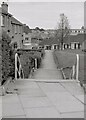
Path from Ramsay Gardens
Looking down the stepped path to Ramsay Crescent.
Image: © Richard Sutcliffe
Taken: Unknown
0.03 miles
2
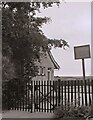
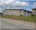
Way in to the Kaimhill Centre
The building is the pavilion used by bowlers using the bowling greens.
The sign reads:
City of Aberdeen
KAIMHILL CENTRE
BOWLS TENNIS PUTTING
OPEN MAY TO SEPT.
VISITORS WELCOME
Image: © Richard Sutcliffe
Taken: Unknown
0.08 miles
3
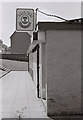
The Copper Beech
A bar on Auchinyell Road, Aberdeen, selling Lorimer's beers. The building was burnt down in 2008 and a social housing development was built on the site.
Image: © Richard Sutcliffe
Taken: Unknown
0.09 miles
4
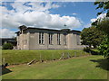
Garthdee Parish Church
Now a shared parish with Ruthrieston West Church: http://www.geograph.org.uk/photo/3511533 . Update: the church was demolished in 2020 and the site is now proposed for housing (as of March 2023).
Image: © Bill Harrison
Taken: 16 Jun 2013
0.11 miles
5
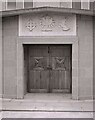
Entrance, Garthdee Parish Church
The church dates from 1952 and is of concrete construction.
The inscription over the doors:
'NEC TAMEN CONSUMEBATUR'
roughly translates as: Nec: it was not; tamen: however; consumebatur: it was consumed.
The wording refers to the Book of Exodus in the Bible when Moses encountered the burning bush. No matter how much it burned, it was never consumed by the flames.
The central emblem above the wording (between a cross and a dove of peace) represents the burning bush. These are emblems used by the Church of Scotland.
Apparently in recent years it became clear that hundreds of thousands of pounds of urgent repairs were required to the building. Local organisations and members of the church attempted to save the building in 2018 after it was announced it could be knocked down due to the high cost and the dropping numbers in the congregation. The church has now been empty since 2020, and it looks like it will be demolished and the land used for redevelopment.
Image: © Richard Sutcliffe
Taken: Unknown
0.12 miles
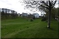
7
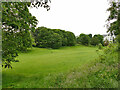
Open space alongside the Deeside Way, Mannofield
Image: © Stephen Craven
Taken: 4 Jul 2019
0.12 miles
8
Sheltered Housing for the Welfare State III
Image: © Bill Harrison
Taken: 16 Jun 2013
0.12 miles
9
Park, Garthdee
Between the Deeside Railway trackbed and Auchenyell Road.
Image: © Richard Webb
Taken: 4 Apr 2017
0.12 miles
10
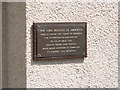
Sheltered Housing for the Welfare State V
Dedication plaque on the almshouse-inspired building.
Image: © Bill Harrison
Taken: 16 Jun 2013
0.12 miles