IMAGES TAKEN NEAR TO
Union Grove, ABERDEEN, AB10 6SY
Introduction
This page details the photographs taken nearby to Union Grove, AB10 6SY by members of the Geograph project.
The Geograph project started in 2005 with the aim of publishing, organising and preserving representative images for every square kilometre of Great Britain, Ireland and the Isle of Man.

There are currently over 7.5m images from over14,400 individuals and you can help contribute to the project by visiting https://www.geograph.org.uk
Image Map
Images are licensed for reuse under creativecommons.org/licenses/by-sa/2.0
Notes
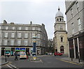
- Clicking on the map will re-center to the selected point.
- The higher the marker number, the further away the image location is from the centre of the postcode.
Image Listing (199 Images Found)
Images are licensed for reuse under creativecommons.org/licenses/by-sa/2.0
Image
Details
Distance
1
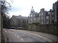
A bend in the lane
Approaching the end of Albyn Lane and the last of the traffic calming 'bumps'; A church dome looms ahead; the place of worship (City of God) fronts onto Holburn St beyond.
Image: © Stanley Howe
Taken: 18 Apr 2013
0.01 miles
2
Holburn Street granite block
Typical of Aberdeen construction some 110-120 years ago (from 2013).
Image: © Bill Harrison
Taken: 2 Mar 2013
0.02 miles
3
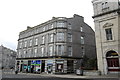
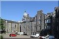
The former St Nicholas Union Grove Church, Aberdeen
Residential flats on Holburn Street (A9013) since the 1970s
Image: © Stanley Howe
Taken: 7 Jun 2014
0.02 miles
4
Holburn Street, Aberdeen (North End)
Holburn Street runs for over 1.5 miles from Aberdeen City Centre to the Bridge of Dee. This shot was taken near the junction with Union Grove at approximately NJ932056.
Image: © Richard Slessor
Taken: 13 Nov 2005
0.02 miles
5
Service yard for businesses on Holburn Street
The dome belongs to a charismatic church: https://portal.historicenvironment.scot/designation/LB47927 .
Image: © Bill Harrison
Taken: 17 May 2024
0.02 miles
6
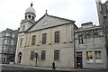
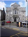
Walking past the City of God, Holburn Street, Aberdeen
The former Holburn Central (Church of Scotland) Parish Church; B-listed: http://www.britishlistedbuildings.co.uk/sc-47927-holburn-street-at-alford-lane-holburn-cen . The listing explains why the buildings bear no fewer than four different date stones (1891 on the tower beneath the cupola, 1836 and 1903 on the main pediment and 1881 on the annex to the right).
Image: © Bill Harrison
Taken: 2 Mar 2013
0.03 miles
7
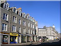
Former Union Grove Church, Holburn Street, Aberdeen
Converted to flats; C-listed: http://www.britishlistedbuildings.co.uk/sc-48523-union-grove-at-holburn-street-1-18-inclus ; Egyptian detailing (compare: http://www.geograph.org.uk/photo/3119829 ).
Image: © Bill Harrison
Taken: 2 Mar 2013
0.03 miles
8
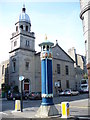
Ventilator Shaft, Justice Mill Lane
Art Nouveau structure at the corner of Holburn Street and Justice Mill Lane. It provided air for a cable subway which ran from here to the old Electricity Works and Tramcar Depot at the foot of Crown Street.
Image: © Colin Smith
Taken: 6 Aug 2009
0.03 miles
9
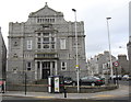
City Junction
Justice Mill Lane meets Holburn Street. The brightly painted ornate tower on the traffic island is an old ventilator (C-listed: http://www.britishlistedbuildings.co.uk/sc-45663-justice-mill-lane-and-holburn-street-vent ) for an underground cable railway which ran from here to the former GPO on Crown Street and to the former tramways depot at Millbank Street. Across the road, the tower of the former Holburn Central Church can be seen.
Image: © Bill Harrison
Taken: 2 Mar 2013
0.03 miles
10
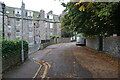
Turf Zone "AlbynZone"
On Albyn Lane, Aberdeen.
Image: © Ian S
Taken: 4 Oct 2022
0.03 miles