IMAGES TAKEN NEAR TO
Waverley Place, ABERDEEN, AB10 1XH
Introduction
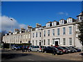
This page details the photographs taken nearby to Waverley Place, AB10 1XH by members of the Geograph project.
The Geograph project started in 2005 with the aim of publishing, organising and preserving representative images for every square kilometre of Great Britain, Ireland and the Isle of Man.

There are currently over 7.5m images from over14,400 individuals and you can help contribute to the project by visiting https://www.geograph.org.uk
Image Map
Images are licensed for reuse under creativecommons.org/licenses/by-sa/2.0
Notes
- Clicking on the map will re-center to the selected point.
- The higher the marker number, the further away the image location is from the centre of the postcode.
Image Listing (212 Images Found)
Images are licensed for reuse under creativecommons.org/licenses/by-sa/2.0
Image
Details
Distance
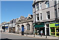
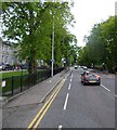
1
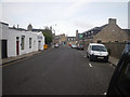
Waverley Place not far from Union Street shopping area
Photographer is standing on the paved street surface.
Image: © C Michael Hogan
Taken: 12 Jun 2011
0.01 miles
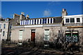
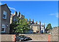
2
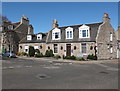
Granite cottages, Victoria Street, Aberdeen
Dating from about 1850, both little (see: http://www.britishlistedbuildings.co.uk/sc-20590-19-victoria-street-including-boundary-wal ) and big (see: http://www.britishlistedbuildings.co.uk/sc-20589-17-victoria-street-including-boundary-wal ) are C-listed.
Image: © Bill Harrison
Taken: 28 Apr 2013
0.03 miles
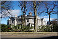
3
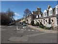
Victoria Street, Aberdeen
A handsome Victorian granite terrace in the West End.
Image: © Bill Harrison
Taken: 28 Apr 2013
0.04 miles
4
Rubislaw Terrace (east end)
As seen from Rubislaw Place.
Image: © Bill Harrison
Taken: 17 Mar 2013
0.05 miles
5
Offices, Alford Place, Aberdeen
These fine granite offices were no doubt built as townhouses.
Image: © Bill Harrison
Taken: 16 Mar 2014
0.05 miles
6
Aberdeen Unison Office, 7 Alford Place
The 19th Century cottage is C-listed (http://www.britishlistedbuildings.co.uk/sc-47451-7-alford-place-including-boundary-walls- ), although the dormer windows don't enhance its appearance.
Image: © Bill Harrison
Taken: 16 Mar 2014
0.06 miles
7
20 and 22 Waverley Place, Aberdeen
The B-listed Prince Regent Hotel dating from ca. 1855: http://www.britishlistedbuildings.co.uk/sc-20596-20-and-22-waverley-place-prince-regent-ho/osmap .
Image: © Bill Harrison
Taken: 16 Mar 2014
0.07 miles
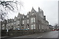
8
Alford Place Free Presbyterian Church
For the history of the sect, see: http://en.wikipedia.org/wiki/Free_Presbyterian_Church_of_Scotland . The building was originally the annex to Christ's College (Aberdeen Free Church theological college) across the road. B-listed: http://www.britishlistedbuildings.co.uk/sc-20087-2-alford-place-alford-place-church-former .
Image: © Bill Harrison
Taken: 25 May 2013
0.07 miles
9
Albyn Place traffic lights
Outside St Margaret's School (off left).
Image: © Stanley Howe
Taken: 30 May 2015
0.07 miles
10
Rubislaw Terrace
This is the north side of the buildings that make up Rubislaw Terrace. Many of the buildings have been extended or altered, and the majority now seem to be offices rather than residential.
Image: © Anne Burgess
Taken: 13 Aug 2024
0.08 miles