IMAGES TAKEN NEAR TO
McCombies Court, ABERDEEN, AB10 1AW
Introduction
This page details the photographs taken nearby to McCombies Court, AB10 1AW by members of the Geograph project.
The Geograph project started in 2005 with the aim of publishing, organising and preserving representative images for every square kilometre of Great Britain, Ireland and the Isle of Man.

There are currently over 7.5m images from over14,400 individuals and you can help contribute to the project by visiting https://www.geograph.org.uk
Image Map
Images are licensed for reuse under creativecommons.org/licenses/by-sa/2.0
Notes
- Clicking on the map will re-center to the selected point.
- The higher the marker number, the further away the image location is from the centre of the postcode.
Image Listing (946 Images Found)
Images are licensed for reuse under creativecommons.org/licenses/by-sa/2.0
Image
Details
Distance
1
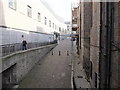
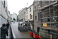
Netherkirkgate, Aberdeen
This ancient Aberdeen street is now flanked by Markies (Marks and Spencer) to the left. The bollards roughly mark the spot where Carnegie's Brae begins, which burrows under Union Street to emerge at the indoor market. There is said to be a nightclub lurking somewhere down there, too.
Image: © Bill Harrison
Taken: 21 Sep 2013
0.00 miles
2
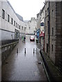
Site of Netherkirkgate Port
Carnegies Brae off right; Ye Olde Frigate Bar ahead right.
Image: © Stanley Howe
Taken: 8 Apr 2009
0.01 miles
4
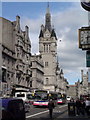
Union Street, Aberdeen
The tower is part of the Town House.
Image: © Mike Pennington
Taken: 8 May 2009
0.01 miles
6
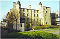
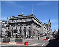
Provost Skene's House.
This rubblestone building is one of the oldest left in Aberdeen. It was formerly houses in the old town, then became a lodging house. Today it houses one of the city's museums with period displays in each room. There is also a fine cafe on the ground floor which sells fine cakes and rowies!
Image: © Colin Smith
Taken: Unknown
0.02 miles
7
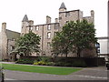
Provost Skene's House, Aberdeen
"This elegant 16th century town house now contains an attractive series of period room settings, recalling the graceful furnishings of earlier times. The displays include a suite of 17th century rooms, a Regency Parlour and an Edwardian Nursery." - information from Aberdeen Art Gallery and Museums. We have two other photos of the house, Image and Image The latter was taken in 1992, the trees have grown since then.
Image: © David Hawgood
Taken: 10 Sep 2007
0.02 miles
8
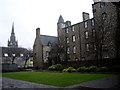
Provost Skene's House
For this (the oldest surviving house in Aberdeen) see https://en.wikipedia.org/wiki/Provost_Skene
Image: © Stanley Howe
Taken: 8 Apr 2009
0.02 miles
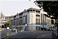
9
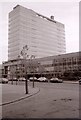
St Nicholas House
Aberdeen City Council's main office accommodation. Demolished in 2013.
Image: © Richard Sutcliffe
Taken: Unknown
0.02 miles
10
The glory of granite (Aberdeen style)
Buildings lining the north side of Union Street at its eastern end; Clydesdale Bank, various shops and commercial buildings and the massive tower of the town house. The road is designated the A9013, which according to the SABRE website, is the highest-numbered A-road in the UK: https://www.sabre-roads.org.uk/wiki/index.php?title=A9013 .
Image: © Bill Harrison
Taken: 12 Jul 2020
0.02 miles