St Mary's church - war memorial
Introduction
The photograph on this page of St Mary's church - war memorial by Evelyn Simak as part of the Geograph project.
The Geograph project started in 2005 with the aim of publishing, organising and preserving representative images for every square kilometre of Great Britain, Ireland and the Isle of Man.

There are currently over 7.5m images from over 14,400 individuals and you can help contribute to the project by visiting https://www.geograph.org.uk
St Mary's church - war memorial
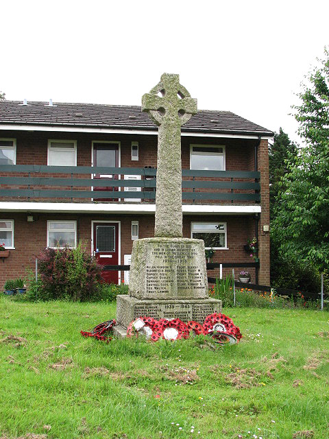
Image: © Evelyn Simak Taken: 18 Jun 2008
The war memorial is located in the southeastern corner of the churchyard surrounding St Mary's > http://www.geograph.org.uk/photo/850766. A 'church without land' is recorded in the Domesday book and it is believed that the old church or chapel that stood on this site marks the spot where King Edmund was interred and martyred in 869. St Mary's church > http://www.geograph.org.uk/photo/850777 - http://www.geograph.org.uk/photo/850800 has a lead-covered bell-turret with a spire; the small church is somewhat dwarved by the large, two-storeyed porch which has an upstairs room; nave and chancel walls are Saxon and the north aisle dates from the 14th century, as does the octagonal font > http://www.geograph.org.uk/photo/850796. The lattice screen at the east end of the north aisle is modern > http://www.geograph.org.uk/photo/850783 - http://www.geograph.org.uk/photo/850794. A chantry chapel, which was added later and now houses the church organ, is separated from the chancel by an unusual stone screen. There is a low side window in the south chancel wall > http://www.geograph.org.uk/photo/850789 with the original shutter hinges still in place. The double piscina has a stone credence shelf in one half > http://www.geograph.org.uk/photo/850790. Other survivals are two old brasses, one to a rector, Richard de Thaseburgh (1389), mounted on the north wall > http://www.geograph.org.uk/photo/850793. The church was extensively restored during the 19th century when it also received a new roof and the current floor tiles. The east window > http://www.geograph.org.uk/photo/850786 is by A.L. Wilkinson (1942). The church is kept locked. Planning permission has just been received for a proposed extension to the church, which will see the addition of toilets, a kitchen, a meeting room and storage space. The funds were raised by the Friends of St Mary’s Church, a registered charity actively engaged in raising funds for the maintenance and enhancement of the church fabric. Hellesdon is a large suburb of Norwich. Signs of very early settlement, such as a variety of flint tools (believed to be at least 4,000 years old) have been unearthed in the area. Bronze axe heads were found near Hellesdon Hall and a skeleton dating from around 600 CE was discovered in Low Road. It is not clear where the old name for Hellesdon - Hailesduna - originates from. It is believed that Edmund, the King of the East Angles, may have been martyred here. In 985, Abbo of Fleury, who at Ramsey Abbey (Cambridgeshire) compiled the 'Life of St Edmund', writes that he heard the Archbishop relate a story that came from a young man who had heard it from a very old man who claimed to have been King Edmund's armour bearer at the time of his death. On his capture, Edmund was whipped and tied to a tree, and shot with arrows. He was then beheaded and his head thrown into a bramble thicket in Hegelisdun Wood - hence the association with Hailesduna, present-day Hellesdon. The King's head was later found, guarded by a wolf, and according to the story the body was buried in a small chapel built nearby for the purpose. The site of the chapel is believed to be the site where St Mary's church stands. The church and the dead body of King Edmund, guarded by a wolf, are depicted on the village sign > http://www.geograph.org.uk/photo/850757.
Images are licensed for reuse under creativecommons.org/licenses/by-sa/2.0
Image Location
Latitude
52.648385
Longitude
1.251345