Sherborne houses [2]
Introduction
The photograph on this page of Sherborne houses [2] by Michael Dibb as part of the Geograph project.
The Geograph project started in 2005 with the aim of publishing, organising and preserving representative images for every square kilometre of Great Britain, Ireland and the Isle of Man.

There are currently over 7.5m images from over 14,400 individuals and you can help contribute to the project by visiting https://www.geograph.org.uk
Sherborne houses [2]
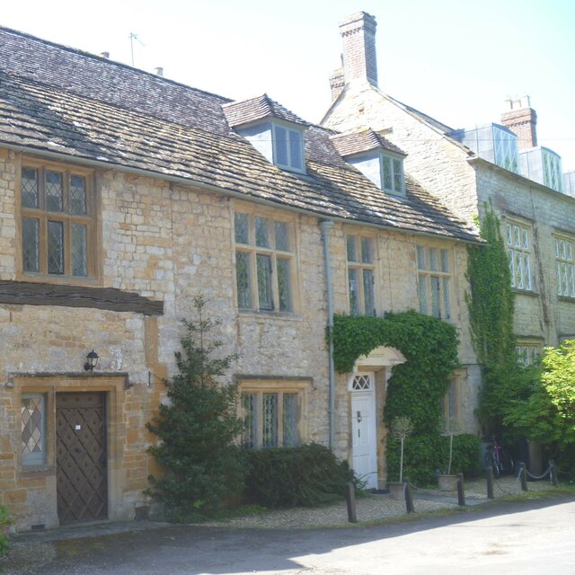
Image: © Michael Dibb Taken: 20 May 2023
Middle House, Castleton Road, was built in the 17th century. Constructed of coursed, squared rubble stone with ashlar dressings under a roof partly of stone slate and partly of tile. The doorway has a pediment supported on brackets. Listed, grade II, with details at: https://historicengland.org.uk/listing/the-list/list-entry/1324340 Sherborne is a market town in northwest Dorset, on the north bank of the River Yeo and Astride the A30 road. It is some 5 miles east of Yeovil and about 16¾ miles north of Dorchester. The town was named scir burne by the Saxons, a name meaning "clear stream", after a brook that runs through the centre of the town, and is mentioned in the Domesday Book. Sherborne Abbey, otherwise the Abbey Church of St. Mary the Virgin has been a Saxon cathedral, a Benedictine abbey church, and, since 1539, a parish church.
Images are licensed for reuse under creativecommons.org/licenses/by-sa/2.0
Image Location


Leaflet Map data © OpenStreetMap
Latitude
50.949271
Longitude
-2.505003