Shropshire Union Canal by Pendeford Park in Wolverhampton
Introduction
The photograph on this page of Shropshire Union Canal by Pendeford Park in Wolverhampton by Roger Kidd as part of the Geograph project.
The Geograph project started in 2005 with the aim of publishing, organising and preserving representative images for every square kilometre of Great Britain, Ireland and the Isle of Man.

There are currently over 7.5m images from over 14,400 individuals and you can help contribute to the project by visiting https://www.geograph.org.uk
Shropshire Union Canal by Pendeford Park in Wolverhampton
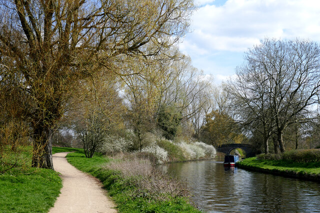
Image: © Roger Kidd Taken: 8 Apr 2023
Looking south-east towards Barnhurst Bridge*, No 2. When the canal was opened in 1835, land on both sides here belonged to Barnhurst Farm, which Wolverhampton Corporation subsequently bought in 1867. Fields by the canal were then transformed into a sewage farm by 1870. The previously old moated Barnhurst Farm was demolished in 1963 and a new one built, but by the early-mid 1970s all the farm land south of the canal was transformed into the Dovecotes housing estate. At the same time, plans were initiated into developing the land at Wolverhampton Airport, which was closed on 31 December 1970, resulting in two adjacent estates between the Shropshire Union and Staffordshire and Worcestershire canals. The park serves all three areas of housing now known as Pendeford. http://historywebsite.co.uk/articles/Pendeford/Barnhurst.htm *Note: Nicholson's popular waterways guides from the 1990s onwards call this Bathurst Bridge, and I assume the CanalPlan website has sourced this for their listing. I can find no evidence for what I suspect was a typographical error in the production of the guide books. Barnhurst Bridge is a more likely name, being just 420 yards north-west of the original Barnhurst Farm. https://maps.nls.uk/geo/explore/#zoom=17.0&lat=52.62022&lon=-2.15519&layers=168&b=1
Images are licensed for reuse under creativecommons.org/licenses/by-sa/2.0
Image Location
Latitude
52.620706
Longitude
-2.154021