Richmond features [9]
Introduction
The photograph on this page of Richmond features [9] by Michael Dibb as part of the Geograph project.
The Geograph project started in 2005 with the aim of publishing, organising and preserving representative images for every square kilometre of Great Britain, Ireland and the Isle of Man.

There are currently over 7.5m images from over 14,400 individuals and you can help contribute to the project by visiting https://www.geograph.org.uk
Richmond features [9]
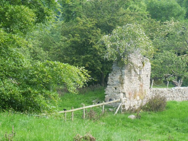
Image: © Michael Dibb Taken: 22 Jun 2022
A glimpse, from Rimington Avenue, of the ruined remains of St Martin's Priory (Benedictine), a small medieval monastic house. Built in the 12th century, or possibly earlier, and added to in the 15th century. Constructed of sandstone rubble stone with ashlar dressings. Some of the stone has been reused for field and garden walls, but the main ruins are a tower, possibly a gatehouse, and the western section of rectilinear structure, probably the church, linked by a wall. See also Image Listed, grade I, with details at: https://historicengland.org.uk/listing/the-list/list-entry/1131548 A Scheduled Ancient Monument, with details at: https://historicengland.org.uk/listing/the-list/list-entry/1012995 Richmond is a picturesque market town in North Yorkshire, some 13 miles northwest of Northallerton and about 11½ miles southwest of Darlington. Set on the north bank of the River Swale, the town is on the edge of the Yorkshire Dales National Park, and is marketed as the Gateway to the Dales. Richmond was founded in 1071 and the castle was completed in 1086. Tourism is important to the local economy, as is the influence of the nearby Catterick Garrison army base. A traditional market operates every Saturday in the large cobbled marketplace.
Images are licensed for reuse under creativecommons.org/licenses/by-sa/2.0
Image Location
Latitude
54.401639
Longitude
-1.72778