
Conflicting Signs
Introduction
The photograph on this page of Conflicting Signs by Ian Dodds as part of the Geograph project.
The Geograph project started in 2005 with the aim of publishing, organising and preserving representative images for every square kilometre of Great Britain, Ireland and the Isle of Man.

There are currently over 7.5m images from over 14,400 individuals and you can help contribute to the project by visiting https://www.geograph.org.uk
Conflicting Signs
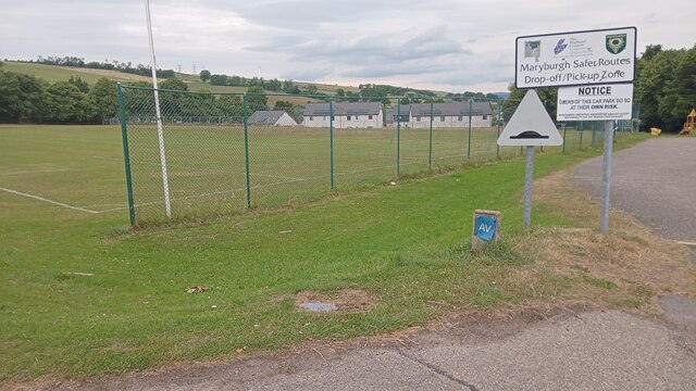
Image: © Ian Dodds Taken: 17 Jul 2022
It turns out that the 'Safer Routes' sign has something to do with creating safer journeys to and from school for children in the Highlands - in this case I imagine younger children attending school in nearby Dingwall or Conon Bridge are picked up and dropped off here by buses, so that they don't need to cross the busy roundabout just North of here unsupervised. It may just be a coincidence, but the local free newsletter, which seems to have something to do with Maryburgh Community Council, is called 'The Roundabout'. Community councils, of which there are over a thousand in Scotland, are non-statutory and voluntary. They occupy a bit of a grey area in local administration; although they have no actual power, they must be consulted on any changes proposed by local government before decisions are finalised, and their views must legally be taken into account, even if not necessarily acted upon. A cynic would argue that they are a way for local authorities to get things done without paying anyone to do it - eg a local authority might agree to provide funding for floral displays through a village, so long as the volunteers do all the planting and maintaining themselves. However, they do provide an efficient line of communication between small communities and often distant local governments. They are quite rightly encouraged in the Highlands for this reason - despite containing less than 5% of Scotland's population, the Highland local (or unitary, as it is officially called) authority covers a third of its area.
Images are licensed for reuse under creativecommons.org/licenses/by-sa/2.0
Image Location

Latitude
57.574551
Longitude
-4.442015