West Ealing's Parliamentary train
Introduction
The photograph on this page of West Ealing's Parliamentary train by Mark Percy as part of the Geograph project.
The Geograph project started in 2005 with the aim of publishing, organising and preserving representative images for every square kilometre of Great Britain, Ireland and the Isle of Man.

There are currently over 7.5m images from over 14,400 individuals and you can help contribute to the project by visiting https://www.geograph.org.uk
West Ealing's Parliamentary train
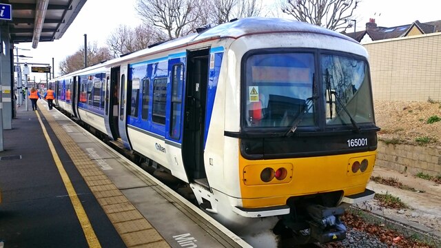
Image: © Mark Percy Taken: 2 Feb 2022
What is this Chiltern Railways diesel multiple unit doing at West Ealing Station - nowhere near its usual route into Marylebone? It's the weekly 'Parliamentary train' to West Ruislip. The service has been through a number of permutations over the years. At the time of writing it was running on Wednesdays only at 1117 non-stop from West Ealing to West Ruislip. The aim is to familiarise Chiltern drivers with working the Greenford branch line in case regular services to and from Marylebone have to be diverted to Paddington in an emergency. Before 2018 the service started at Paddington and ran the entire length of the Acton to Northolt Line (then known as the 'New North Main Line'), but when the line was severed for HS2 construction, the ghost train was diverted to start from West Ealing instead. The weekly train ran non-stop to High Wycombe before being reduced to terminate at West Ruislip in December 2021. 'Parliamentary trains' began in the 1840s as statutory minimum services providing inexpensive transport for less affluent passengers. The Railway Regulation Act stipulated that at least one such service be run each day on each route. These days the term describes services that continue to run - typically once a week - to avoid the cost of formally closing a route or station. These 'ghost trains' have acquired a cult following among rail enthusiasts.
Images are licensed for reuse under creativecommons.org/licenses/by-sa/2.0
Image Location
Latitude
51.513586
Longitude
-0.321499