Map and Information on Penn Village inside a telephone box
Introduction
The photograph on this page of Map and Information on Penn Village inside a telephone box by David Hillas as part of the Geograph project.
The Geograph project started in 2005 with the aim of publishing, organising and preserving representative images for every square kilometre of Great Britain, Ireland and the Isle of Man.

There are currently over 7.5m images from over 14,400 individuals and you can help contribute to the project by visiting https://www.geograph.org.uk
Map and Information on Penn Village inside a telephone box
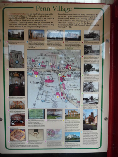
Image: © David Hillas Taken: 30 Jun 2022
This photo shows a map provided by Penn Parish Council and fixed inside the red telephone box in Penn village. It has the following wording round the map: Heading Penn Village This red telephone box you are standing in was designed by Sir Giles Gilbert Scott in 1935, and was made a Grade II listed building in 1989. The small green with its war memorial is Penn's historic village centre, surrounded by the 12th-century church & graveyard, vicarage, school (now the church hall), almhouses, 16th-century pub, a pound for stray animals, a cluster of old cottages including the Parish Room from where the church Vestry administered the parish, and a grand house which once belonged to the manorial family. Almost all the buildings are Listed and are in a Conservation Area. No shops survive. The bench outside was put up for the Queen's Coronation in 1953, made from teak taken from the SS Atlantis (1913-52). Photos above map from left to right i) Penn School (blue dot) Now the Church hall and Penn Parish Council office, stands on the site of the earlier Parish Workhouse. Built in 1839 by the 1st Earl Howe, in memory of his wife, as a working school for girls, designed by Edward Blore who later designed the front of Buckingham Palace for Queen Victoria. Tudor style with imported yellow brick. Extended in 1910, by which time there were boys as well as girls. Closed in 1949. ii) Almhouses (Brown dot) In 1831, following serious rioting by labourers in neighbouring Loudwater and Wycombe Marsh "an asylum for the indigent poor of the parish" was built at the expense of Earl Howe and Thomas Grove of Watercroft. Pulled down in 1967 and replaced by the present Penn Mead flats designed by Sir Hugh Casson. iii) The Crown (Red dot) One of two alehouses recorded in Penn in 1577. The oldest part is 16th-century, of red and grey brick and an external chimney, with 18th-century and later additions. Once an inn with five bedrooms. Owned by the Penn House Estate, it hosted large shooting parties and Estate rent suppers. During WWII it was the Home Guard 'local'. The Darvill family were landlords for over a century from 1750. Then the Garlands from 1864 until 1934, when the Inn was sold. Photos left of map reading downwards i) Penn Church (Pink dot) Remembrance Sunday with flags in memory of American crew of the Tomahawk Warrior, US Flying Fortress bomber which crashed in Penn in 1944. ii) Tower Clock (Pink dot) One-handed tower clock of Penn Parish Church (1715). iii) The late 12th-century nave (Pink dot) The nave dates from 1177. The font, consecration crosses and stone tomb are also late 12th-century. The fine queen-post roof is c.1400. The Doom can be seen above the chancel arch. iv) 15th-century rare Doom painting (Pink dot) One of only five surviving wooden tympanums in the country, it is a 12 foot wide painting of the "Last Judgement" on oak panels (V&A Image Copyright Penn PCC) v) William Penn the Quaker, founder of Pennsylvania (Pink dot) Six grandchildren are buried in a family vault under the centre of the nave. vi) 14th-century Penn tiles in the Lady Chapel (Pink dot) Vast quantities of decorated floor tiles and roof tiles were made for royal palaces and major churches all over London and the south-east of England. The tilers gave their name to Tylers Green. Photos right of map reading downwards i) Home Guard (Red dot) No.5 (Penn) Platoon, 'B' Company, 5th Battalion Home Guard outside the Crown in March 1944, led by Lt.S.A.Jollye. ii) The Pound (Red dot) A pound was a feature of most villages from the medieval period. It was an enclosure where stray livestock, sheep, pigs and cattle, found anywhere in the parish, were impounded until claimed by their owners, usually for the payment of a fine to the offended landowner and to the pound-keeper, or eventually sold to cover the costs. This most recent pound was a small, square, brick and flint enclosure built in 1870 and dismantled in 1907. It is now part of The Crown's car park. iii) Stock elms c.1910? (Green dot) The small village green was once the place for the stocks beneath two very old elm trees, still known as stock elms when the last one finally collapsed in 1997 with Dutch Elm disease. Stocks were boards into which a malefactor's feet were locked as a punishment leaving the person open to public humiliation or worse. They were required by law in every town and village for over 500 years and the law has never been revoked. Their last remembered use here was c.1860s. iv) Penn School children on the Green, early 1900s (Green dot) v) Village Green and War Memorial (Green dot) Village Green and War Memorial put up after WWI by public subscription. Earl Howe donated the land, a London architect was engaged, and it was unveiled by Field Marshal Sir William Robertson, head of the British Army 1916-18 on 10 April 1921. The names of those killed in WWII were added after 1945. vi) Pauls Hill Cottages with Parish Room (Blue dot) Pauls Hill is lined with 16th-18th century brick & flint listed cottages, often concealing earlier timber-framing. The cottage on the right was the Parish Room, converted c.1730 from a 16th- century timber-framed house. It was called the Parish Pay Room and was used by the Vestry for poor relief administration and was where parish taxes were set, collected and disbursed. The poor rate was paid out monthly to the poor, who could represent up to a quarter of the parish after a bad harvest. Cottages for the parish poor were also built by 1744, some of them in Beacon Hill. The track at one side of the parish room led to the manor house at Penbury. The Parish Room was also used as a lace school and a Sunday School. At one time there was a shop and a pub at the back. In 1894, the first election for a Parish Council took place there and subsequent meetings took place by gaslight, with payment of florins into a meter, until 2002 when the building was converted into an office. In 1995, parish records dating as far back as 1698 were found in an old locked safe. Photos below the map, top three from left to right i) Gravestone - Dr Louisa Garrett Anderson (Pink dot) Daughter of Elizabeth Garrett Anderson, the first qualified woman doctor. She and her friend, Dr Flora Murray, both active suffragettes, set up the first hospital in London staffed only by women to treat WWI casualties. Donald Maclean, the Russian spy who defected in 1951 is buried with his parents and brother. In the graveyard extension, designed by Sir Edward Maufe: David Blakeley who was shot in 1955 by Ruth Ellis, the last woman to be hanged in England, and Alison Uttley, author of "Little Grey Rabbit" fame. ii) Grave Yard (Pink dot) William Penn, lord of the manor, who died in 1693, has the earliest marked grave in the corner of the south side of the chancel and Lady Chapel. iii) The Knoll (Yellow dot) A fine house south of the churchyard, built in 1671 for the newly-wed Nathaniel Curzon and Sarah Penn. External brick walls support the roof, but the interior is supported by a heavy oak frame. It has original casement windows on the north side. On the west side is a tiled turret probably built as an observatory by the Rev Benjamin Anderson (1733-1823), a friend of Edmund Burke, who described him in letters to the Home Secretary and Secretary at War in 1795 as "a Clergyman at Penn...of Learning and Merit...whose observatory and Experimental apparatus I wished much to show you...". The Countess Howe, divorced wife of the 5th Earl, moved to the house in 1945, followed by her son the 6th Earl. After nearly three centuries of Curzon ownership, the house was sold in 1956. Photos below the map, lower three from left to right i) Edward III on a nave roof corbel (Pink dot) He purchased ¼ million decorated Penn paving tiles for Windsor Castle, as well as large quantities of floor and roof tiles for other royal palaces and mansions. ii) View from Penn Church Tower (Pink dot) It was claimed in 1802 that on a clear day 12 counties could be seen. The map shows the extent of a 40 mile radius. The Home Guard in WW2 had an observation post at the top of the tower using a wooden sentry box for their nightly watch. They could see the outskirts of London as well as American planes landing at Brackley in Northamptonshire, 40 miles away. iii) Old Vicarage (Pale green dot) Built in 1825, at the expense of the Vicar with '6 bedchambers, 2 dressing rooms and a water closet'. There was an underground passage from the cellar of the house to the church vestry, apparently blocked up in the 1960s. King William IV and Queen Adelaide visited the house and the church in 1833 & 1835. The Vicar moved to a new but smaller house in 1925.
Images are licensed for reuse under creativecommons.org/licenses/by-sa/2.0
Image Location
Latitude
51.631142
Longitude
-0.676809