Information Board at Little Kingshill
Introduction
The photograph on this page of Information Board at Little Kingshill by David Hillas as part of the Geograph project.
The Geograph project started in 2005 with the aim of publishing, organising and preserving representative images for every square kilometre of Great Britain, Ireland and the Isle of Man.

There are currently over 7.5m images from over 14,400 individuals and you can help contribute to the project by visiting https://www.geograph.org.uk
Information Board at Little Kingshill
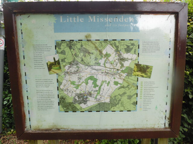
Image: © David Hillas Taken: 30 Jun 2022
This information board is by the recreation ground in Windsor Lane HP16 0DZ and has the heading "Little Missenden and its footpaths. The map in the middle shows the area that the parish of Little Missenden covers including Holmer Green, Hyde Heath, Little Kingshill and Little Missenden. The wording on the left of the map is as follows: The Parish Church of St John the Baptist Over a thousand years old, Little Missenden Parish Church is famous for its wall paintings dating from the 13th century. The church itself dates from Saxon times (950-1050AD) and was originally built with Roman bricks. However it has been enlarged many times over the centuries. There is also an early map of the Parish on the wall of Lady Chapel. The River Misbourne The river flow is somewhat erratic, occasionally drying up completely. Excellent views over the valley may be seen from the South Bucks Way between Little Missenden and Little Kingshill. There were once watercress beds near Suffolk Bridge and water mills at Deep Mill and Little Missenden. Of the 13th century Deep Mill only the mill pond remains. The mill itself finally disappeared about the time the railway was built (early 1890s). Little Missenden water mill is first mentioned in 1352, the present building is mainly 17th century and ceased using water in about 1920. Latterly, it was augmented by a steam engine, its chimney still survives and is now a private house. The wording on the right of the map is as follows: Since prehistoric times In about the 12th century there was a Motte and Bailey castle in Hyde Heath, although all that can now be seen are the remains of the earthworks a few feet high, visible from Church Lane. It once probably had a tower on top of the motte. There is a leaflet available showing all the parish footpaths. Please call at Little Missenden Parish Office, Rossetti Hall, 38 New Pond Road, Holmer Green, HP15 6SU. 1) Full Moon Public House, Little Kingshill 2) The Plough Public House, Hyde Heath 3) St Andrews Church, Hyde Heath 4) St John the Baptist Church, Little Missenden 5) Red Lion Public House, Little Missenden 6) The Crown Public House, Little Missenden 7) Christ Church, Holmer Green 8) Bat and Ball Public House, Holmer Green 9) Old Oak Public House, Holmer Green 10) Earl Howe Public House, Holmer Green public footpaths public bridleways south bucks way picnic areas parking recreation areas woodland Wording below the map: This map is reproduced from Ordnance Survey material with the permission of Ordnance Survey on behalf of the Controller of Her Majesty's Stationery Office c Crown Copyright. Unauthorised reproduction infringes Crown copyright and may lead to prosecution or civil proceedings. enjoy our parish and please follow the country code...take only photographs and leave only footprints
Images are licensed for reuse under creativecommons.org/licenses/by-sa/2.0
Image Location
Latitude
51.682479
Longitude
-0.708582