Information Board at Penny's Corner, Bourne End
Introduction
The photograph on this page of Information Board at Penny's Corner, Bourne End by David Hillas as part of the Geograph project.
The Geograph project started in 2005 with the aim of publishing, organising and preserving representative images for every square kilometre of Great Britain, Ireland and the Isle of Man.

There are currently over 7.5m images from over 14,400 individuals and you can help contribute to the project by visiting https://www.geograph.org.uk
Information Board at Penny's Corner, Bourne End
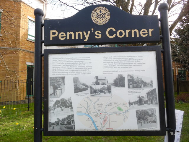
Image: © David Hillas Taken: 10 Mar 2022
This information board has been erected by Wooburn & Bourne End Parish Council and is located in Station Road (A4094) near the junction with Cores End Road. It shows a map of Bourne End with words and photos surrounding it. It has the following wording: Previously the Nag's Head public house stood on this important junction where the road from Cookham connected with the route into Marlow and provided access to riverside wharves. From a small cluster of cottages called Bone End, the arrival of the railway created a local station called Marlow Road and later changed to Bourne End. With it came business and recreation. Lloyds Bank was built in 1925 with endless fields behind. The Parade of shops on the left towards Marlow is dated 1902. Business developed around the railway station, the tavern became a hotel, riverside land was developed, papermills expanded to meet industrial needs and the Victorian and Edwardian love of day trips brought visitors in their hundreds to enjoy boating. Sometime after the end of the Second World War the Nag's Head public house was demolished and the land acquired by Bucks County Council. Plans to develop with shops and flats caused a local outcry as the land had been cultivated by former parish council chairman, Penny Walsh, and her husband Brian. Eventually, it was bought by the parish council and officially named Penny's Corner. i) Three photos on the left with the wording 'The Parade from the 1920s and 1930s' ii) Three photos above the map with the wording 'Views of the Nag's Head pub from the 1920s and 1930s (note fields in the background)' iii) Top and middle photos to the right of the map with wording 'Bourne End Station, Railway Hotel and Nag's Head Pub-note train en route to High Wycombe early 1900s' iv) One lower photo to the right of the map with the wording 'Hedsor Road and Red Lion Pub in 1905'
Images are licensed for reuse under creativecommons.org/licenses/by-sa/2.0
Image Location
Latitude
51.578016
Longitude
-0.710535