Methodist Church, Main Street, Higham on the Hill
Introduction
The photograph on this page of Methodist Church, Main Street, Higham on the Hill by Jo and Steve Turner as part of the Geograph project.
The Geograph project started in 2005 with the aim of publishing, organising and preserving representative images for every square kilometre of Great Britain, Ireland and the Isle of Man.

There are currently over 7.5m images from over 14,400 individuals and you can help contribute to the project by visiting https://www.geograph.org.uk
Methodist Church, Main Street, Higham on the Hill
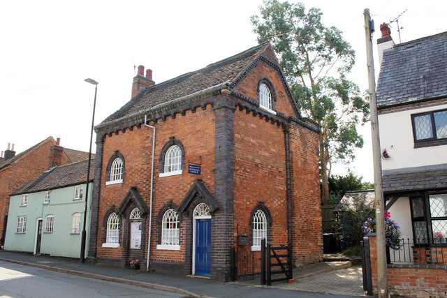
Image: © Jo and Steve Turner Taken: 4 Aug 2021
Grade II Listed mid 19th century Methodist Church. Originally ‘the house that Jack built’. The deeds go back to 1838 when Jack Brown pushed a hand cart to and from Wilnecote Brick Works, a distance of 10 miles, carrying all the bricks to build a house. The iron window frames he carried from Birmingham a 42 mile round trip for each frame. After 14 years the house still needed a roof which was paid for by the parish. Sadly, Jack never lived to enjoy the fruits of his labours. It has two front doors, two rear doors and two internal staircases but has always been one house. It was purchased in 1959 and converted into the Methodist Chapel. (The OS map shows it as 66 Main Street but a number of websites give the address as 68).
Images are licensed for reuse under creativecommons.org/licenses/by-sa/2.0
Image Location
Latitude
52.555471
Longitude
-1.438889