Old Boundary Marker on Station Hill, Redruth
Introduction
The photograph on this page of Old Boundary Marker on Station Hill, Redruth by R Guy as part of the Geograph project.
The Geograph project started in 2005 with the aim of publishing, organising and preserving representative images for every square kilometre of Great Britain, Ireland and the Isle of Man.

There are currently over 7.5m images from over 14,400 individuals and you can help contribute to the project by visiting https://www.geograph.org.uk
Old Boundary Marker on Station Hill, Redruth
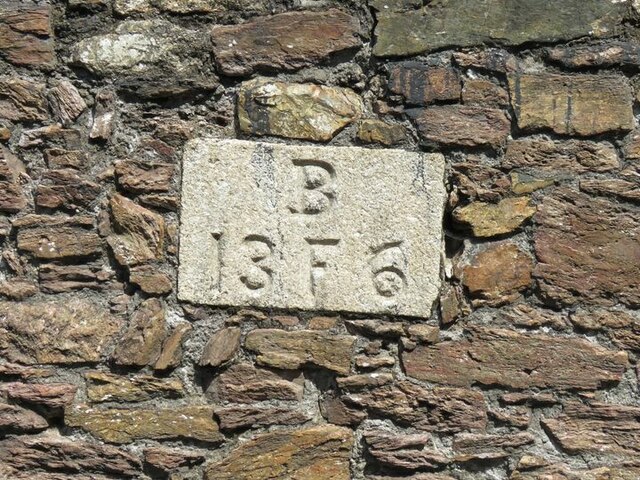
Image: © R Guy Taken: 30 Jun 2021
Mine Boundary Marker set in the south face of a stone wall beside Station Hill. Redruth parish. Inscribed B / 13 F 6. The wall was the boundary of Fair Meadow and the stone records the Basset sett boundary. Three other stones with similar inscriptions are also set in the wall. HER MCO56306, see https://www.heritagegateway.org.uk/Gateway/Results_Single.aspx?uid=MCO56306&resourceID=1020&fbclid=IwAR3LpurQ8IV4zcq-f-9liWiK62o05iVnMXme-t7R2osiw2_X_nDqiXfvhxE. Milestone Society National ID: CW_REDRU01em
Images are licensed for reuse under creativecommons.org/licenses/by-sa/2.0
Image Location
Latitude
50.232234
Longitude
-5.227908