Information Board re The Wendover Arm (2)
Introduction
The photograph on this page of Information Board re The Wendover Arm (2) by David Hillas as part of the Geograph project.
The Geograph project started in 2005 with the aim of publishing, organising and preserving representative images for every square kilometre of Great Britain, Ireland and the Isle of Man.

There are currently over 7.5m images from over 14,400 individuals and you can help contribute to the project by visiting https://www.geograph.org.uk
Information Board re The Wendover Arm (2)
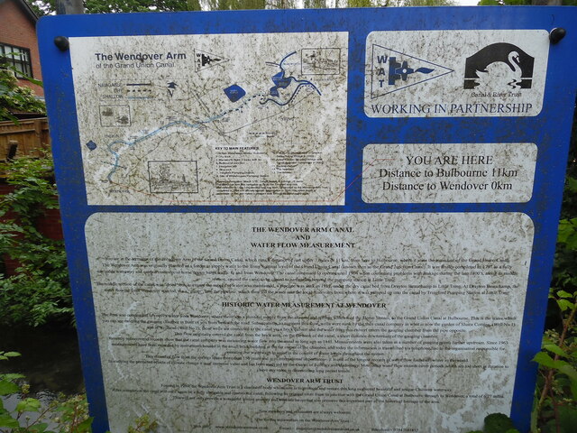
Image: © David Hillas Taken: 19 Jun 2021
This information board is located by the Wendover Arm near Wharf Road. It has the following wording: Top Left Map of the Wendover Arm of the Grand Union Canal with Key to Main Features 1) British Waterways Works, Bulbourne 2) Dry dock 3) Marsworth flight. 7 locks 42ft 3in 4) Bulbourne Junction 5) Heygates Mill 6) Stop lock 7) Tringford Pumping Station 8) Site of Whitehouses Pumping Station 9) The Sump. Moved east of Drayton Beauchamp Bridge in 2003. 10) Aston Clinton By-Pass Bridge and canal diversion completed in 2003. 11) Bucklandwharf 12) The Narrows 13) The Wides Opened to navigation: March 1797. Length 6 miles, 6 furlongs 28 yards The Wendover Arm was navigable as far as the Tringford stop-lock. The extension to Little Tring winding hole has been constructed by the Wendover Arm Trust, completed in 2004 and officially opened to navigation in 2005. The entire length is accessible on foot and makes a pleasant walk through beautiful countryside. Top Right YOU ARE HERE Distance to Bulbourne 11km Distance to Wendover 0km Lower section THE WENDOVER ARM CANAL AND WATER FLOW MEASUREMENT You are at the terminus of the Wendover Arm of the Grand Union Canal which runs a distance of just under 7 miles or 11km, from here to Bulbourne, where it joins the main line of the Grand Union Canal. The Wendover Arm was originally planned as a feeder to supply water to the Tring Summit level of the Grand Union Canal (known then as the Grand Junction Canal). It was finally completed in 1797 as a fully navigable waterway and carried commercial horse drawn barge traffic to and from Wendover. The canal continued to operate until 1904 when continuing problems with leakage during the late 1800's, along its middle section, caused the canal to be closed to navigation beyond the pumping station at Little Tring. The middle section of the canal was "dried" but to ensure the supply of water was maintained, a pipeline was sunk in 1912 under the dry Canal from Drayton Beauchamp to Little Tring. At Drayton Beauchamp, the water flowing from Wendover was fed, via a "sump" into the pipeline, which then fed the water into the local reservoirs from where it was pumped up into the canal by Tringford Pumping Station at Little Tring. HISTORIC WATER MEASUREMENT AT WENDOVER The Arm was constructed to convey water from Wendover, where there was a plentiful supply from the streams and springs which feed the Heron Stream, to the Grand Union Canal at Bulbourne. This is the water which you can see entering the gauging chamber in front of you from beneath the road. Subsequently, to augment this flow, wells were sunk by the then canal company in what is now the garden of Sluice Cottage (Well No1) and at Wellhead (Well No2); these wells are connected to the canal via a brick culvert and the water from this culvert enters the gauging chamber from the pipe opposite. This flow originally entered the canal from the brick arch, on the far bank of the canal, a short distance downstream of the gauging chamber. Recently rediscovered records show that the canal company was measuring water flow into the canal as long ago as 1841. Measurements were also taken at a number of gauging points further upstream. Since 1963 measurements have been recorded by instruments housed in the small brick building at the far corner of the chamber, and today the information is transmitted via telephone line to the organisation responsible for operating our waterways to assist in the control of water levels throughout the system. This record of flow from the springs spans more than 150 years and is of international importance. It is one of the longest records of water flow found anywhere in the world. In studying the predicted effects of climate change it is of immense value and has been analysed by the Centre of Ecology and Hydrology. Most other water flow records cover periods which are too short in duration to have any value in determining long period trends. WENDOVER ARM TRUST Formed in 1989, the Wendover Arm Trust is a charitable body whose aim is to promote and restore this long neglected beautiful and unique Chilterns waterway. After completion the canal will once again be a fully navigable and operational canal, following its original route from its junction with the Grand Union Canal at Bulbourne through to Wendover a total of 6.77 miles. This will not only provide a wonderful leisure amenity and wild life haven but also preserve this important part of the historical heritage of the area. New members and volunteers are always welcome.
Images are licensed for reuse under creativecommons.org/licenses/by-sa/2.0
Image Location
Latitude
51.765827
Longitude
-0.741275