Sikh monument, junction of Stoney Stanton Road, Bell Green Road and Jimmy Hill Way, Coventry
Introduction
The photograph on this page of Sikh monument, junction of Stoney Stanton Road, Bell Green Road and Jimmy Hill Way, Coventry by A J Paxton as part of the Geograph project.
The Geograph project started in 2005 with the aim of publishing, organising and preserving representative images for every square kilometre of Great Britain, Ireland and the Isle of Man.

There are currently over 7.5m images from over 14,400 individuals and you can help contribute to the project by visiting https://www.geograph.org.uk
Sikh monument, junction of Stoney Stanton Road, Bell Green Road and Jimmy Hill Way, Coventry
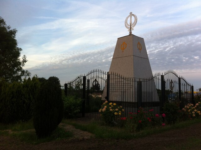
Image: © A J Paxton Taken: 14 Jun 2021
Not a rose garden in Chandigarh, but a roundabout in Coventry: a monument erected by Coventry Sikhs on the elevated ground of a roundabout in the middle of a major road junction. The inscription reads: THIS MONUMENT, SHOWING THE SYMBOLS OF THE SIKH REGIMENT, WAS ERECTED BY THE SIKH COMMUNITY OF COVENTRY, WITH KIND PERMISSION OF COVENTRY CITY COUNCIL, FOLLOWING THE TRICENTENNIAL ANNIVERSARY OF THE CREATION OF THE KHALSA." Beneath this is written, "THE FOUNDATION STONE LAID DOWN ON 11 - 2 - 2002 COMPLETED 30 - 6 - 2002" The monument takes the form of a truncated pyramid faced with granite and topped with a finial in the form of the khanda, the modern emblem of the Sikh faith and community. The khanda emblem also appears on the metalwork of the gates and fence enclosing the monument, while on the granite sheets of the upper part of the monument appears a gold emblem with the vertical khanda sword and chakkar quoit of the khanda, but without the encircling pair of kirpan swords. The khanda emblem appears on the Nishan Sahib, the sacred banner flown by Sikh places of worship: for a detailed account of its development and symbolism, see here http://www.sikhmuseum.com/nishan/index.html
Images are licensed for reuse under creativecommons.org/licenses/by-sa/2.0
Image Location
Latitude
52.430183
Longitude
-1.485927