Cirencester houses [72]
Introduction
The photograph on this page of Cirencester houses [72] by Michael Dibb as part of the Geograph project.
The Geograph project started in 2005 with the aim of publishing, organising and preserving representative images for every square kilometre of Great Britain, Ireland and the Isle of Man.

There are currently over 7.5m images from over 14,400 individuals and you can help contribute to the project by visiting https://www.geograph.org.uk
Cirencester houses [72]
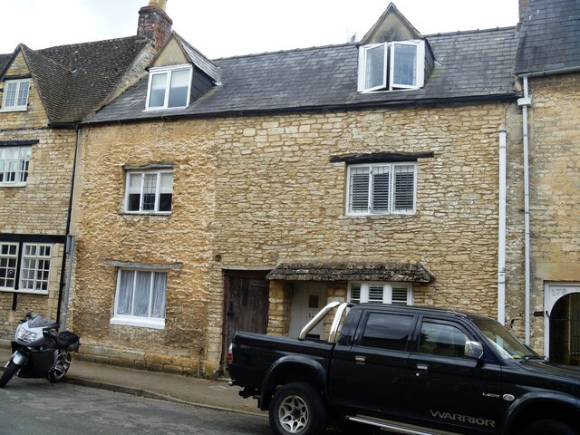
Image: © Michael Dibb Taken: 12 May 2021
Numbers 175 and 177 Gloucester Street are a pair of houses built in the late 17th or early 18th century. Constructed of coursed rubble stone under a Welsh slate roof. The (probably 18th century) door to the left gives access to a through passage and the entrance to No.175 is off this passage. Listed, grade II, with details at: https://historicengland.org.uk/listing/the-list/list-entry/1206138 Cirencester, the largest town in the Cotswolds, is a market town some 15 miles south east of Gloucester and some 13 miles north west of Swindon. The town lies on the River Churn, a tributary of the River Thames and is the hub of a network of roads. It is the home of the Royal Agricultural University, founded in 1840. An important Roman settlement known as Corinium, the town, with 240 acres enclosed by walls was second only to London in size.
Images are licensed for reuse under creativecommons.org/licenses/by-sa/2.0
Image Location
Latitude
51.72212
Longitude
-1.973315