St George The Martyr Tower, St George's Street, Canterbury
Introduction
The photograph on this page of St George The Martyr Tower, St George's Street, Canterbury by Jo and Steve Turner as part of the Geograph project.
The Geograph project started in 2005 with the aim of publishing, organising and preserving representative images for every square kilometre of Great Britain, Ireland and the Isle of Man.

There are currently over 7.5m images from over 14,400 individuals and you can help contribute to the project by visiting https://www.geograph.org.uk
St George The Martyr Tower, St George's Street, Canterbury
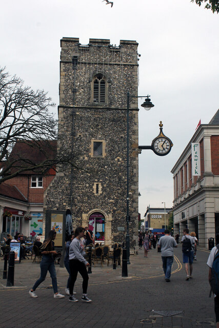
Image: © Jo and Steve Turner Taken: 8 Jul 2016
Scheduled Monument and Grade II Listed tower. It is possible a Saxon church stood around here but a late Iron Age or early Roman ditch was found under the church, probably a field boundary. The archaeological assessment favoured that the first church would be of post conquest date. Earliest evidence dates a church back to the 11th century that was expanded in the 12th to 14th century. The tower is late 14th or early 15th century with some Norman remains and was situated at the north-west end of the church. In 1788 an arched passage was opened through the ancient round tower attached to the southeast corner of the steeple for passage of foot passengers that weakened it such that this stair tower was removed in 1794 and the square tower made good with a pointed spire of wood on top. It was reported in 1833 that 'A grand improvement has been made in the interior of St. George's church'. It was expanded in 1872 (according to a brass plaque in 1905) to accommodate the parishioners when St Mary Magdalene church closed (1866) and was largely demolished in 1871. A clock was added in 1836 and Kelly's 1882 directory includes 'a clock which was restored in 1877 and two four feet projecting illuminated dials added by Gillett, Bland & Co. Croydon' then around 1906 a clock face was made by William Biggleston and a bracket was made by Herbert Biggleston. It was restored again in the 1950s probably at time of the church demolition and then again in 2010. On 1st June 1942 the whole area suffered serious damage in an air raid and the church stood as a shell until demolished in 1955 leaving just the tower.
Images are licensed for reuse under creativecommons.org/licenses/by-sa/2.0
Image Location
Latitude
51.277465
Longitude
1.082564