Inverted benchmark on Railway Bridge TJC3/88 Carleton Road
Introduction
The photograph on this page of Inverted benchmark on Railway Bridge TJC3/88 Carleton Road by Roger Templeman as part of the Geograph project.
The Geograph project started in 2005 with the aim of publishing, organising and preserving representative images for every square kilometre of Great Britain, Ireland and the Isle of Man.

There are currently over 7.5m images from over 14,400 individuals and you can help contribute to the project by visiting https://www.geograph.org.uk
Inverted benchmark on Railway Bridge TJC3/88 Carleton Road
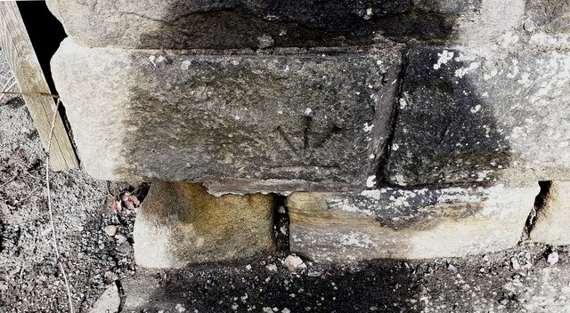
Image: © Roger Templeman Taken: 4 Mar 2021
Ordnance Survey cut mark benchmark shown as deleted on the Ordnance Survey Benchmark Locator with details SD 9875 5102 N PARA RLY BR CARLETON RD W SIDE RLY S FACE 0.5m above ground 108.426m above Newlyn Datum. Apparently the parapet was rebuilt and the stone with the benchmark inverted to indicate the benchmark invalidated.
Images are licensed for reuse under creativecommons.org/licenses/by-sa/2.0
Image Location


Leaflet Map data © OpenStreetMap
Latitude
53.955361
Longitude
-2.020536