Commemorative Marker on the A682 Gisburn Road at Blacko
Introduction
The photograph on this page of Commemorative Marker on the A682 Gisburn Road at Blacko by D Phillips as part of the Geograph project.
The Geograph project started in 2005 with the aim of publishing, organising and preserving representative images for every square kilometre of Great Britain, Ireland and the Isle of Man.

There are currently over 7.5m images from over 14,400 individuals and you can help contribute to the project by visiting https://www.geograph.org.uk
Commemorative Marker on the A682 Gisburn Road at Blacko
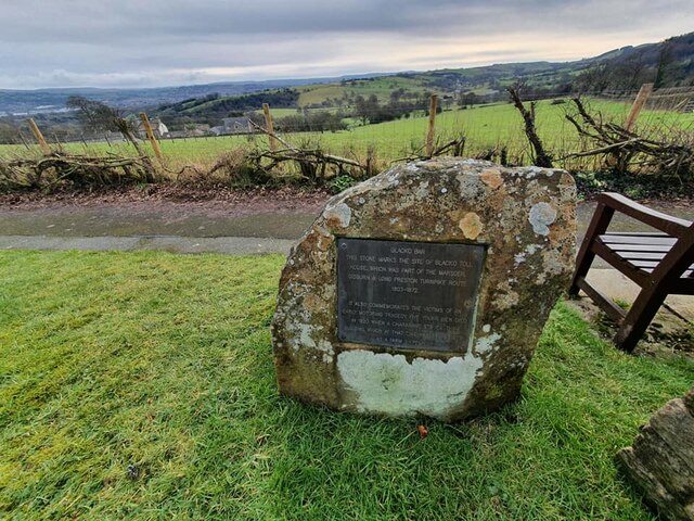
Image: © D Phillips Taken: Unknown
Commemorative Marker on the south side of the T junction of the A682 Gisburn Road and Blacko Bar Road. Blacko parish. Inscribed BLACKO BAR / THIS STONE MARKS THE SITE OF BLACKO TOLL / HOUSE, WHICH WAS PART OF THE MARSDEN / GISBURN & LONG PRESTON TURNPIKE ROUTE / 1803 - 1872 / IT ALSO COMMEMORATES THE VICTIMS OF AN / EARLY MOTORING TRAGEDY. FIVE YOUNG MEN DIED / IN 1920 WHEN A CHARABANC STRUCK THE / BUILDING, WHICH AT THAT TIME WAS BEING USED / AS A FARM SHIPPON. Milestone Society National ID: LA_BLACKO01cm
Images are licensed for reuse under creativecommons.org/licenses/by-sa/2.0
Image Location
Latitude
53.872746
Longitude
-2.223153