Bury St Edmunds buildings [54]
Introduction
The photograph on this page of Bury St Edmunds buildings [54] by Michael Dibb as part of the Geograph project.
The Geograph project started in 2005 with the aim of publishing, organising and preserving representative images for every square kilometre of Great Britain, Ireland and the Isle of Man.

There are currently over 7.5m images from over 14,400 individuals and you can help contribute to the project by visiting https://www.geograph.org.uk
Bury St Edmunds buildings [54]
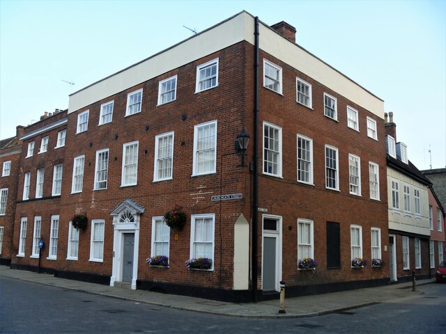
Image: © Michael Dibb Taken: 11 Sep 2020
The statutory address is 37 Churchgate Street but the main frontage is to Chequer Square. Probably originally built as a house in the mid 18th century in red brick the building became a public House, The Six Bells Inn. Later it became a Masonic Hall and was converted to residential use in the early 2010s. Listed, grade II, with details at: https://historicengland.org.uk/listing/the-list/list-entry/1248209 Crown Street is an historic street that starts with a brewery and finishes with a cathedral, has a medieval graveyard, the second largest parish church in the country and houses from the 16th to the 19th centuries. At its north end it opens out to become Chequer Square. Bury St Edmunds is a market town which is the cultural and retail centre for West Suffolk and is known for brewing (Greene King) and sugar (British Sugar). There is scattered evidence of earlier activity but essentially Bury St Edmunds began as one of the royal boroughs of the Saxons and a monastery was founded which became the burial place of King Edmund. A new Benedictine abbey was built in 1020 which became rich and powerful and the town was laid out on a grid pattern by Abbot Baldwin. After the dissolution the abbey became ruinous. A new church, later the cathedral, was begun in the early 16th century.
Images are licensed for reuse under creativecommons.org/licenses/by-sa/2.0
Image Location
Latitude
52.243623
Longitude
0.716204