Bury St Edmunds Abbey precincts [35]
Introduction
The photograph on this page of Bury St Edmunds Abbey precincts [35] by Michael Dibb as part of the Geograph project.
The Geograph project started in 2005 with the aim of publishing, organising and preserving representative images for every square kilometre of Great Britain, Ireland and the Isle of Man.

There are currently over 7.5m images from over 14,400 individuals and you can help contribute to the project by visiting https://www.geograph.org.uk
Bury St Edmunds Abbey precincts [35]
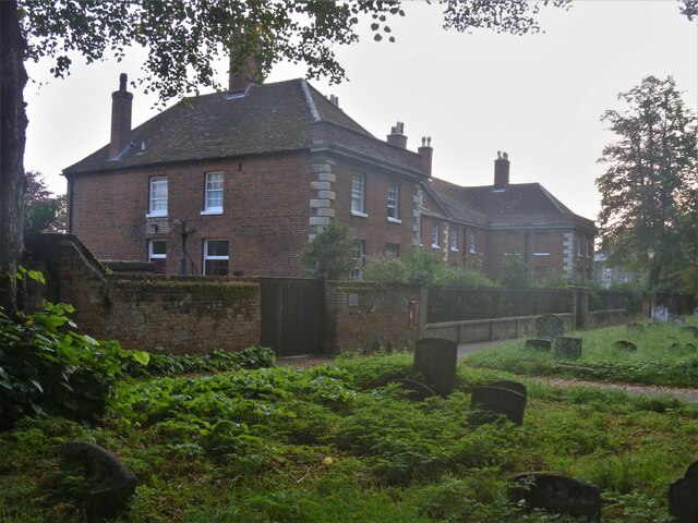
Image: © Michael Dibb Taken: 14 Sep 2020
This property between the abbey ruins and the Great Churchyard has had a number of uses as well as a number of names. Built in red brick with stone dressings, in 1736 as Clopton’s Hospital - almshouses which catered to ‘twelve poor people’, the name changed to Clopton’s Asylum in 1825. It became the vicarage for the church of St James in 1900. When listed by English Heritage it was the Provost's House and Clopton Cottage. An article in Suffolk News in August 2018 stated that an application has been submitted to subdivide The Deanery to create one two-bedroom house and a six-bedroom Deanery, where the new Dean, will stay. Listed, grade I, with details at: https://historicengland.org.uk/listing/the-list/list-entry/1375558 The Abbey Gardens occupy the site of St Edmund's Abbey. In 1953 the Borough bought the Gardens and managed the area around the abbey ruins, thus reuniting the two main parts of the Abbey Precinct - the Abbey Gardens and the Great Churchyard. The gardens are on the Register of Historic Parks and Gardens, grade II, and there is much history and detail at: https://historicengland.org.uk/listing/the-list/list-entry/1001493 Except for the Great Churchyard the site is a Scheduled Ancient Monument and there is much history and detail at: https://historicengland.org.uk/listing/the-list/list-entry/1021450
Images are licensed for reuse under creativecommons.org/licenses/by-sa/2.0
Image Location
Latitude
52.243483
Longitude
0.718393