South Harbour
Introduction
The photograph on this page of South Harbour by Anne Burgess as part of the Geograph project.
The Geograph project started in 2005 with the aim of publishing, organising and preserving representative images for every square kilometre of Great Britain, Ireland and the Isle of Man.

There are currently over 7.5m images from over 14,400 individuals and you can help contribute to the project by visiting https://www.geograph.org.uk
South Harbour
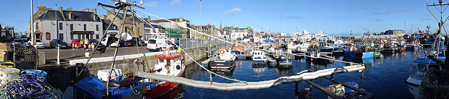
Image: © Anne Burgess Taken: 14 Oct 2020
This is the inner basin of the South Harbour, which dates back to the early 19th century, between the North Pier, reconstructed on the site of an earlier pier in 1807-1812, and the South Pier of about 1822. The Middle Jetty was improved in the 1830s.
Images are licensed for reuse under creativecommons.org/licenses/by-sa/2.0
Image Location
Latitude
57.691753
Longitude
-2.003173