Information Board at Brill Common
Introduction
The photograph on this page of Information Board at Brill Common by David Hillas as part of the Geograph project.
The Geograph project started in 2005 with the aim of publishing, organising and preserving representative images for every square kilometre of Great Britain, Ireland and the Isle of Man.

There are currently over 7.5m images from over 14,400 individuals and you can help contribute to the project by visiting https://www.geograph.org.uk
Information Board at Brill Common
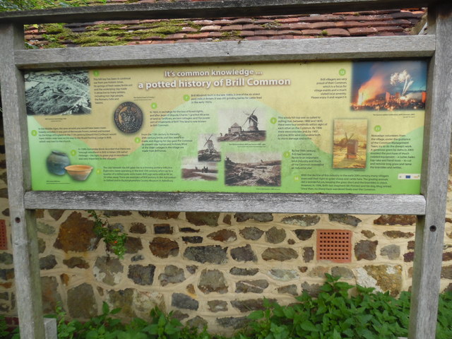
Image: © David Hillas Taken: 11 Sep 2020
This information board is located at South Hills HP18 9TQ and has the following wording: Its common knowledge..... a potted history of Brill Common 1) This hill-top has been in continual use from pre-historic times. Its springs of fresh water, fertile soil and the underlying clay made it attractive to many settlers including Iron Age people, the Romans, Celts and Saxons. 2) In the Middle Ages, the area around you would have been more heavily wooded. It was part of Bernwode Forest owned and hunted by the kings of England. In the 11th century, Edward the Confessor would have ridden near here on his way to the Royal Hunting Lodge in Brill, which was next to the church. 3) In 1086, Domesday Book recorded that there was "enough woodland in Brill to fatten 200 swine". Pannage - the right to graze pigs in woodland - was very important to the villagers. 4) The clay beneath the hill gave rise to a thriving pottery industry. Eight kilns were operating in the mid 13th century, when up to a quarter of a million pots were made. Brill jugs were sold as far as 50 miles away. There are examples of Brill pottery in the Ashmolean in Oxford and in Buckinghamshire County Museum in Aylesbury. 5) From the 15th century to the early 20th century, bricks and tiles were also made, and digging for clay gave the Common its present-day humps and hollows. Most of the older cottages in the village are made from Brill bricks. 6) In 1632, in exchange for the loss of forest rights and after years of dispute, Charles I granted 48 acres of land to "artificers, ancient cottagers and the poorer sort of inhabitants in Brill". This land is now known as Brill Common. 7) Brill Windmill, built in the late 1680s, is one of the six oldest post mills in Britain. It was still grinding barley for cattle feed in the early 1920s. 8) The windy hill-top was so suited to milling that, between 1800 and 1830, there were four windmills within sight of each other on the Common. By 1906, there were only two and, by 1907, just one. Mills were vulnerable both to storm damage and fire. 9) By the 19th century, Brill had become home to an important brick industry, and much of the Common resembled an industrial site! 10) With the decline of this industry in the early 20th century, many villagers exercised their right to graze sheep and cattle here. The grazing animals did a wonderful job, keeping the grass short and the brambles in check. However, in 1996, Brill's last shepherd (Mr Pointer) and his dog, Meg retired. 11) Nowadays, volunteers from the village, under the guidance of the Common Management Team, try to do the sheep's work. A generous grant by defra in 2005 enabled the purchase of much needed equipment - a cutter, baler, hay-rake and hand-tools - to cut and remove long grass and tame the brambles and nettles. 12) Brill villagers are very proud of their Common, which is a focus for village events and a much visited local amenity. Please enjoy it and respect it. Images from left to right i) Brill Common (and sheep) 1981 ii) 14th century Brill pots iii) The Oxford Crown of Charles I iv) Brill Windmill (Nixey's Mill) and Parson's Mill c1900 v) Poore's Brickworks c1900 vi) Brill Windmill vii) The Queen's Jubilee Celebrations, Brill Common, 2002
Images are licensed for reuse under creativecommons.org/licenses/by-sa/2.0
Image Location
Latitude
51.821467
Longitude
-1.056458