The A31 Southampton Road viewed from a Morris 8 - Ringwood 1956 (2)
Introduction
The photograph on this page of The A31 Southampton Road viewed from a Morris 8 - Ringwood 1956 (2) by Ronald Searle as part of the Geograph project.
The Geograph project started in 2005 with the aim of publishing, organising and preserving representative images for every square kilometre of Great Britain, Ireland and the Isle of Man.

There are currently over 7.5m images from over 14,400 individuals and you can help contribute to the project by visiting https://www.geograph.org.uk
The A31 Southampton Road viewed from a Morris 8 - Ringwood 1956 (2)
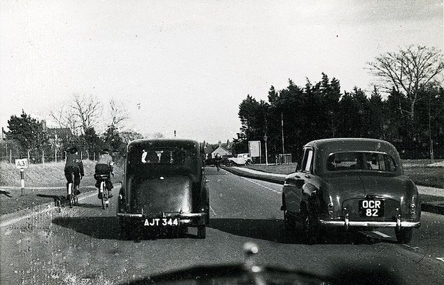
Image: © Ronald Searle Taken: 31 Mar 1956
The modern A31 elevated dual carriageway today carries thousands of vehicles a day past the sleepy market town of Ringwood. In 1955 this was it, a single carriageway seen here eastbound on what was the A31 Southampton Road, on the approach to the junction of Parsonage Barn and Broadshard Lanes beyond the bend. A rather dangerous overtaking manoeuvre is in progress here, whose outcome is unknown, but if I were the approaching solitary cyclist in the opposite carriageway, I would be very, very worried. In 1956 it was still possible for small vehicles to progress along a short disused section of the old Southampton road, and to join the A31 as this car is doing in the far distance behind the lone cyclist. By 1964 and probably earlier, this route was closed off to vehicular traffic. Photographed through the windscreen of my father's Morris 8, reg. no. ERU 765. Image
Images are licensed for reuse under creativecommons.org/licenses/by-sa/2.0
Image Location
Latitude
50.849629
Longitude
-1.784034