Old Milestone by the A243, Hook Road, Surbiton parish
Introduction
The photograph on this page of Old Milestone by the A243, Hook Road, Surbiton parish by C Woodward as part of the Geograph project.
The Geograph project started in 2005 with the aim of publishing, organising and preserving representative images for every square kilometre of Great Britain, Ireland and the Isle of Man.

There are currently over 7.5m images from over 14,400 individuals and you can help contribute to the project by visiting https://www.geograph.org.uk
Old Milestone by the A243, Hook Road, Surbiton parish
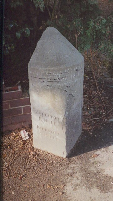
Image: © C Woodward Taken: 29 Dec 2004
Carved stone post by the A243, in parish of SURBITON (KINGSTON UPON THAMES District), Hook Road (Southborough), by No. 80, North of the junction with Herne Road, in tarmac pavement, back to low wall, on West side of road. Chessington peak stone, erected by the Kingston & Leatherhead turnpike trust in the 19th century. Inscription reads:- : SURBITON / 1 MILE / KINGSTON / 2 MILES : : ROYAL EXCHANGE / 15 MILES / WHITEHALL 13¼ MILES / HYDE PARK 12 0 : : LEATHERHEAD / 6 MILES / DORKING / 9 MILES : Milestone Society National ID: SY_KTLH02.
Images are licensed for reuse under creativecommons.org/licenses/by-sa/2.0
Image Location
Latitude
51.378741
Longitude
-0.302468