Old Milestone by the B1383, London Road, Newport parish
Introduction
The photograph on this page of Old Milestone by the B1383, London Road, Newport parish by JV Nicholls as part of the Geograph project.
The Geograph project started in 2005 with the aim of publishing, organising and preserving representative images for every square kilometre of Great Britain, Ireland and the Isle of Man.

There are currently over 7.5m images from over 14,400 individuals and you can help contribute to the project by visiting https://www.geograph.org.uk
Old Milestone by the B1383, London Road, Newport parish
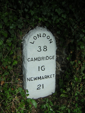
Image: © JV Nicholls Taken: 1 May 2005
Carved stone post by the B1383 (was A11), in parish of NEWPORT (UTTLESFORD District), North of Newport, built into flint wall, on West side of road. Erected by the Hockerill turnpike trust in the 19th century. Inscription reads:- LONDON 38 CAMBRIDGE 16 NEWMARKET 21 Essex HER. SMR Number: 15077 https://www.heritagegateway.org.uk/Gateway/Results_Single.aspx?uid=MEX40580&resourceID=1001 Milestone Society National ID: EX_BSGC38.
Images are licensed for reuse under creativecommons.org/licenses/by-sa/2.0
Image Location


Leaflet Map data © OpenStreetMap
Latitude
51.99881
Longitude
0.212535